299 résultats pour : woodcut map
- Page
-
- sur
- 3
Connectez-vous pour plus de résultats
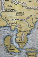
BRK26C62_346
North India, Sumatra, Malaysia, detail, hand-colou...
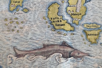
BRK26C56_190
South India, Sumatra, Malaysia, sea monster, detai...

BRK26C04_203
Hermann Ludwig Ferdinand Helmholtz, from 1883 von ...
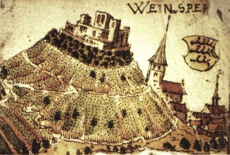
BRK26B77_136
Weinsberg is a town in the district of Heilbronn, ...
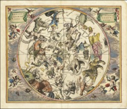
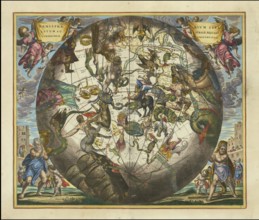
BRK26B12_019
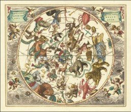
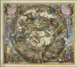
Celestial map entitled Hæmisphærium Stellatum Bore...

BRK26B12_023
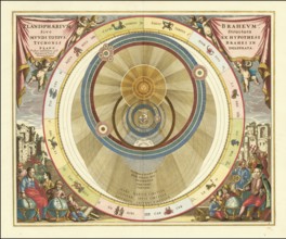
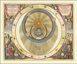
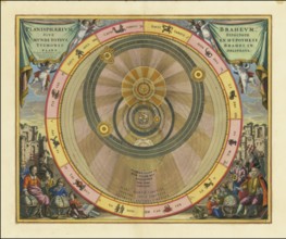
Planisphaerium Braheum, a famous historical celest...
BRK26B12_034
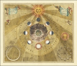
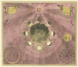
Historical copper engraving entitled Phases of the...

BRK26B12_036
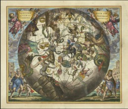
Sky map of the northern sky, known as Hemisphaeriu...
BRK26B12_044
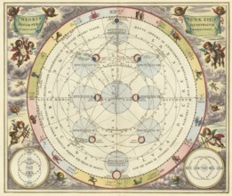
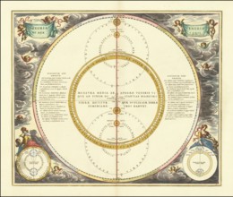
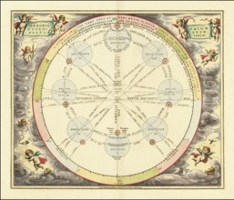
Historical astronomical map Theoria Lunae, Eius Mo...
BRK26B12_035
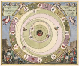
Planisphaerium of Aratos from the famous celestial...
BRK26B12_046
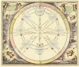
Historical illustration of the orbits of Mercury a...

BRK26B07_430
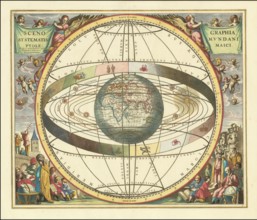
Historical sky map known as Scenographia Systemati...
BRK26B12_025
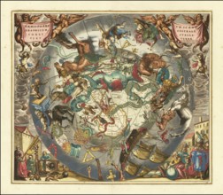
Sky map Hemisphaerii Borealis Coeli et Terrae Spha...
BRK26B12_043
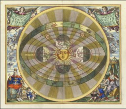
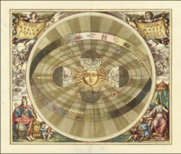
Scenographia Systematis Copernicani, scenography o...

BRK26B12_029
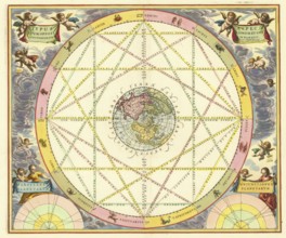
Orbium Planetarum Terram Complectentium Scenograph...
BRK26B07_429
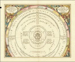
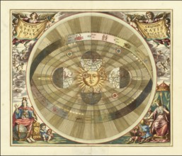
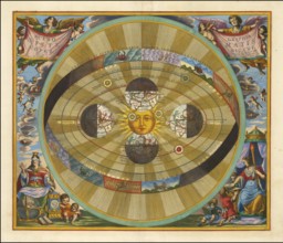
Historical presentation of the tychonic world view...
BRK26B12_022
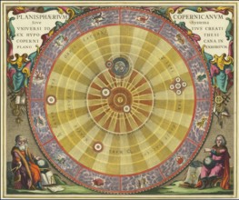
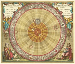
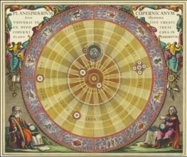
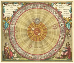
Planisphaerium Copernicanum sky diagram by Andreas...
BRK26B12_027
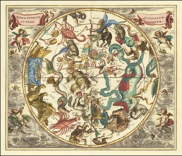
Ancient star map, specifically a depiction of the ...
BRK26B12_040
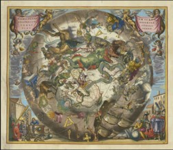
Haemisphaerium Stellatum Boreale Antiquum, a histo...
BRK26B12_041
Scenographia Systematis Copernicani, scenography o...
BRK26B12_030
Planisphaerium Arateum, part of the famous celesti...
BRK26B12_031
A 17th century illustration of Tycho Brahe's geo-h...
BRK26B12_028
Celestial map of the southern hemisphere with the ...
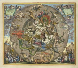
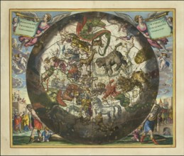
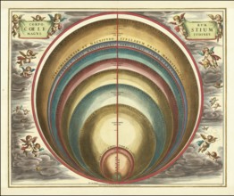
BRK26B12_018
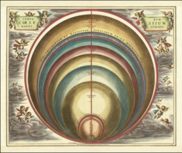
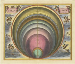
Sky map with the title Corporum Coelestium Magnitu...

BRK26B12_024
Historical celestial map depicting the Ptolemaic, ...
BRK26B12_032
Historical astronomical map titled Planisphaerium ...

BRK26B12_021
Historical sky map with Ptolemy's geocentric world...
BRK26B12_026
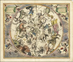
Haemisphaerium Stellatum Boreale cum Subiecto Hæmi...
BRK26B12_039
Historical sky map Haemisphaerium Scenographicum A...
BRK26B12_033
Presentation of the geocentric world view based on...
BRK26B12_017
Historical presentation of the Tychonic world syst...

BRK26B12_038
Historical sky map Corporum Coelestium Magnitudine...
BRK26B12_042
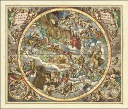
Sky map titled Coeli Stellati Christiani Haemispha...
BRK26B12_047
Historical sky map titled Haemisphaerium Stellatum...
BRK26B12_048
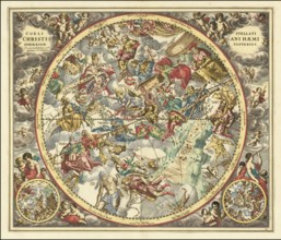
Historical sky map titled Coeli Stellati Christian...
BRK26B12_016
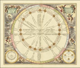
Theoria Trium Superiorum Planetarum sky map, theor...
BRK26B12_020
Historical map titled Scenographia Systematis Cope...
BRK26B12_037
Historical sky map with the title Theoria Solis pe...
BRK26B12_045
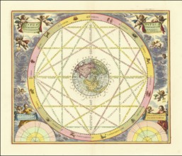
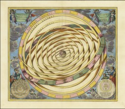
Celestial map Typus Aspectuum Oppositionum et Coni...
BRK26B12_015
Historical astronomical depiction of the phases of...
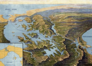
BRK26A05_086
Panama Canal in 1913, map, Panama, authentic repro...

BRK25H78_367
Mathematician monks, one teaching the globe, the o...
BRK25E14_126
Haemisphaerium Stellatum Australe Cum Aequali Spha...
BRK25E19_421
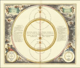
The magnitude of various celestial bodies and star...
BRK25E16_048
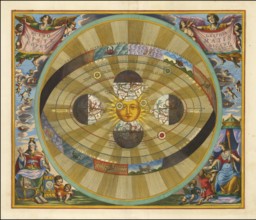
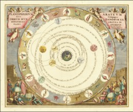
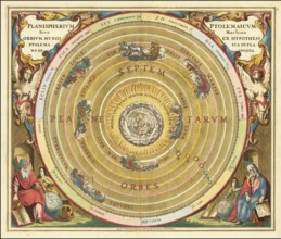
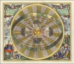
Copernicus' heliocentric model of the universe, 16...
BRK25D82_038
Die Bewegungen von Venus und Merkur, 1660, digital...
BRK25D87_288
Typus Aspectuum Oppositionum Et Coniunctionum Etz ...

BRK25D95_209
The creation of the world, creation story, God in ...
BRK25C76_458
Scenographia Systematis Copernicani, 1660, digital...

BRK25C79_440
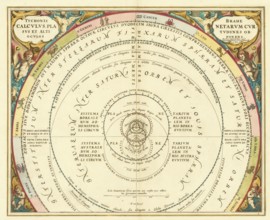
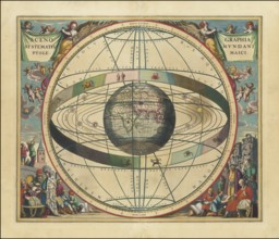
Claudius Ptolemy's geocentric model of the Univers...
BRK25C61_265
Celestial map, Scenographia Systematis Mundani Pto...

BRK25C64_021
Planisphaerium Ptolemaicum, Sive Machina Orbium Mu...
BRK25C78_195
Heliocentric model of the universe, as proposed by...
BRK25C75_196
Danish astronomer Tycho Brahe's model of the unive...
BRK25C61_266
Planisphaerium Copernicanum Sive Systema Universi ...
BRK25C63_023
Corporum Coelestium Magnitudines, 1660, digitally ...
BRK25C89_391
Die Theorie der Epizyklen, 1660, digitally improve...
BRK25C67_386
Planisphaerium Braheum Sive Structura Mundi Totius...
BRK25C67_385
Copernican astronomical chart in the form of the c...
BRK25B97_269
Orbium Planetarum Terram Complectentium Scenograph...
BRK25B41_367
Ptolemaic Solar System, Scenographia Systematis Mu...
BRK25A78_182
Haemisphaerium Scenographicum Australe Coeli Stell...
BRK25A64_207
The constellations of the Northern Hemisphere supe...

BRK25A85_191
Theoria Lunae, Eius Motum Per Eccentricum Et Epicy...

BRK24I73_084
Karl Friedrich Schinkel, 1781-1841, Prussian archi...
BRK24I50_112
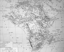
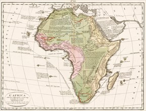
Map of Africa in 1884, Historical, digitally resto...
BRK24H54_053
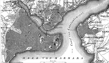
Map of Constantinople, Istanbul, and suburbs and B...

BRK24E75_076
City map of Hamburg, Germany, in 1885, Historical,...
BRK24C52_365
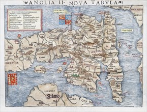
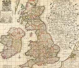
England and Scotland, hand-coloured woodcut map fr...

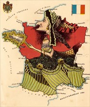
BRK23D34_183
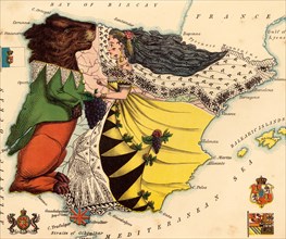
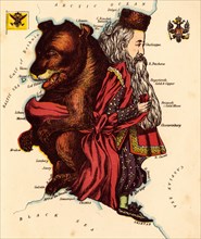
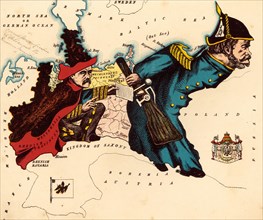
Personified Map
BRK23D34_202
Africa

BRK23D34_184
Personified Map
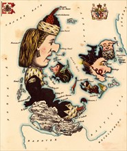
BRK23D34_185
Personified map
BRK23D34_188
Personified map
BRK23D34_197
A new map of England

BRK23D34_186
Personified map
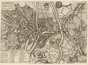
BRK23D42_263
City map
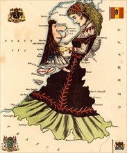
BRK23D34_187
Personified map

BRK23D34_195
Personified map
BRK23D34_194
Personified map

BRK23D34_191
Personified map
BRK23D34_192
Personified map

BRK23D34_189
Personified Map
BRK23D34_190
Personified map
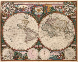
BRK23D34_198
Nova totius terrarum orbis tabula
BRK23B51_040
Atlas, map from 1623, Bavaria, Germany, digitally ...
BRK23B51_041
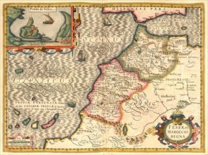
Atlas, map from 1623, Morocco, digitally restored ...
BRK23B54_334
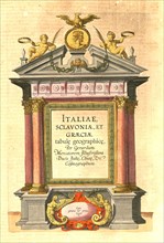
Atlas, map from 1623, Italy, intertitle in the atl...
BRK23B55_039
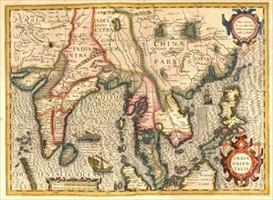
Atlas, map from 1623, Bay of Bengal, India, Siam, ...
BRK23B58_135
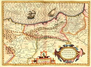
Atlas, map from 1623, Legionis Biscaiae et Guipisc...
BRK23B59_038
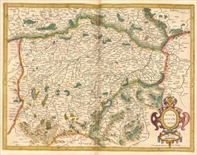
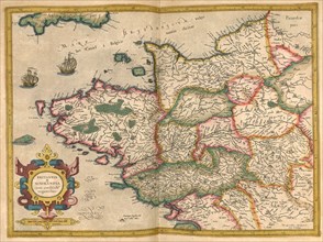
Atlas, map from 1623, Brittany and Normandy, Franc...
BRK23B59_242
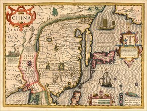
Atlas, map from 1623, China, digitally restored re...
BRK23B59_430
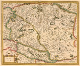
Atlas, map from 1623, Hungary, digitally restored ...
BRK23B60_339
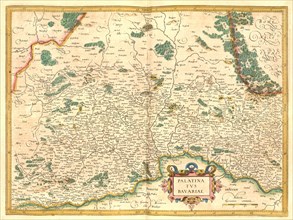
Atlas, map from 1623, Palatina and Bavariae, Palat...
BRK23B60_340
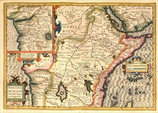
Atlas, map from 1623, Abyssinia, Arabia, Nubia, di...
BRK23B63_038
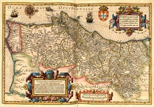
Atlas, map from 1623, Portugal, digitally restored...
BRK23B68_138
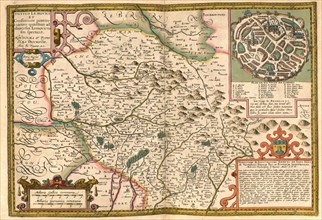
Atlas, map from 1623, Lemovici, France with city o...
BRK23B52_338
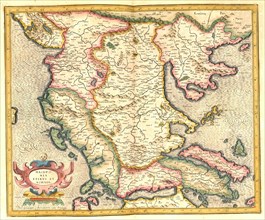
Atlas, map from 1623, Macedonia, digitally restore...
BRK23B52_339
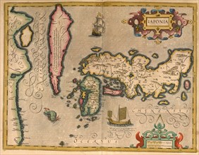
Atlas, map from 1623, Japan, digitally restored re...
BRK23B53_234
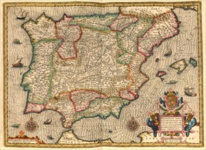
Atlas, map from 1623, Iberian Peninsula, Spain, Po...
- Page
-
- sur
- 3