Période

26 résultats pour : johannes schumacher

  • Page
  • sur
  • 1
Connectez-vous pour plus de résultats
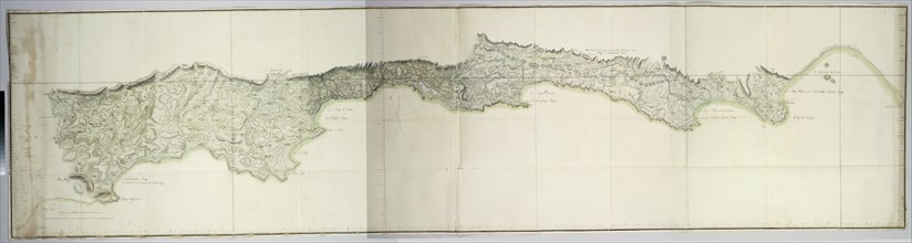
Map of the south coast of South Africa between Cape Agulhas and the Sundays River, after 1789-1790. Creators: Robert Jacob Gordon, Johannes Schumacher.
HRM23A86_220

Map of the south coast of South Africa between Cap...
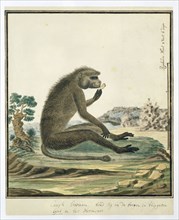
Papio ursinus (Chacma baboon), 1773-1786. Creators: Robert Jacob Gordon, Johannes Schumacher.
HRM23A86_221

Papio ursinus (Chacma baboon), 1773-1786. Creators...
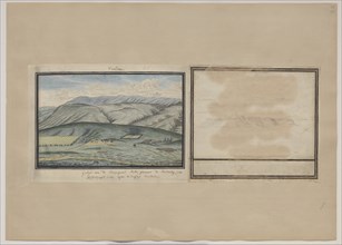
View of the farm of Johannes de Beer at Camdeboo, near the Sneeuberge, seen from the..., c.1777-1778 Creators: Robert Jacob Gordon, Johannes Schumacher.
HRM23A86_231

View of the farm of Johannes de Beer at Camdeboo, ...
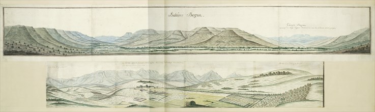
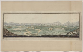
Panorama of the Biedouw and Cuinjis Mountains, c.1778-1779. Creators: Robert Jacob Gordon, Johannes Schumacher.
HRM23A86_240

Panorama of the Biedouw and Cuinjis Mountains, c.1...
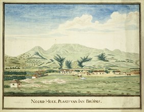
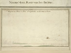
View of the farm of Jan Bruins at Noordhoek, c.1777-1786. Creators: Robert Jacob Gordon, Johannes Schumacher.
HRM23A86_230

View of the farm of Jan Bruins at Noordhoek, c.177...
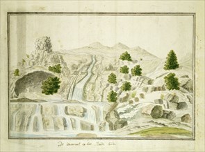
The waterfall at the Roodezand valley, near Tulbagh, 1778-1779. Creators: Robert Jacob Gordon, Johannes Schumacher.
HRM23A86_241

The waterfall at the Roodezand valley, near Tulbag...

The postmaster’s house on Robben Island, seen from the sea, c.1777. Creators: Robert Jacob Gordon, Johannes Schumacher.
HRM23A86_229

The postmaster’s house on Robben Island, seen from...

The Dutch East India Company’s post Rietvlei, near Swellendam, seen from the south, 1777-1778. Creators: Robert Jacob Gordon, Johannes Schumacher.
HRM23A86_238

The Dutch East India Company’s post Rietvlei, near...
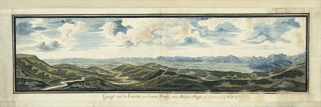
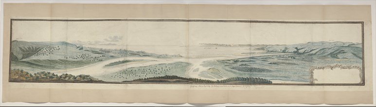
Panorama of the Camdebo and Sneeuberg Mountains, from Bruintjieshoogte Pass, 1777. Creators: Robert Jacob Gordon, Johannes Schumacher.
HRM23A86_243

Panorama of the Camdebo and Sneeuberg Mountains, f...
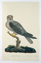
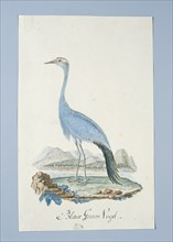
Elanus caeruleus (Black-winged kite), 1777-1786. Creators: Robert Jacob Gordon, Johannes Schumacher.
HRM23A86_228

Elanus caeruleus (Black-winged kite), 1777-1786. C...

Meerhoff's Castle, Namaqualand, 1779. Creators: Robert Jacob Gordon, Johannes Schumacher.
HRM23A86_239

Meerhoff's Castle, Namaqualand, 1779. Creators: Ro...

The Koperberge, near the contemporary Springbok, in little Namaqualand, 1779-1780. Creators: Robert Jacob Gordon, Johannes Schumacher.
HRM23A86_242

The Koperberge, near the contemporary Springbok, i...
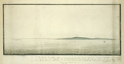
View of Robben Island from a distance of one hour south south-east from the shore, 1777. Creators: Robert Jacob Gordon, Johannes Schumacher.
HRM23A86_227

View of Robben Island from a distance of one hour ...

Valley with twenty-five farmsteads, 1777-1786. Creators: Robert Jacob Gordon, Johannes Schumacher.
HRM23A86_236

Valley with twenty-five farmsteads, 1777-1786. Cre...
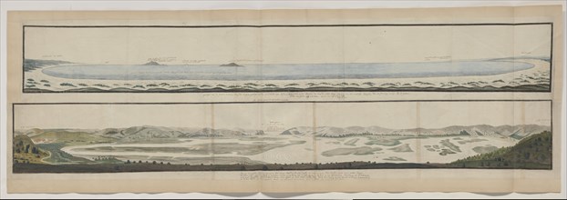
The confluence of the Caledon and Orange Rivers, seen from the south-west, 1777. Creators: Robert Jacob Gordon, Johannes Schumacher.
HRM23A86_245

The confluence of the Caledon and Orange Rivers, s...

View of a saltpan, near the mouth of the Swartkops River, 1778. Creators: Robert Jacob Gordon, Johannes Schumacher.
HRM23A86_226

View of a saltpan, near the mouth of the Swartkops...

View of the Drostdy, 1777-1778. Creators: Robert Jacob Gordon, Johannes Schumacher.
HRM23A86_237

View of the Drostdy, 1777-1778. Creators: Robert J...
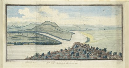
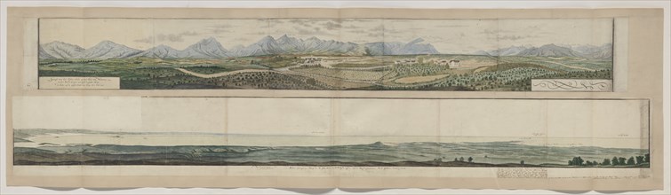
Panorama of the Knysna River and the defile through which it flows into the sea., 1778-1779. Creators: Robert Jacob Gordon, Johannes Schumacher.
HRM23A86_244

Panorama of the Knysna River and the defile throug...
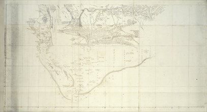
Map of the Southern Part of South Africa, after 1786. Creators: Robert Jacob Gordon, Johannes Schumacher.
HRM23A86_225

Map of the Southern Part of South Africa, after 17...
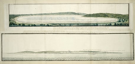
Panorama of Plettenberg Bay, seen from an elevation at the mouth of the Keurbooms River, 1778. Creators: Robert Jacob Gordon, Johannes Schumacher.
HRM23A86_234

Panorama of Plettenberg Bay, seen from an elevatio...

Map of Saldanha Bay, c.1784. Creators: Robert Jacob Gordon, Johannes Schumacher.
HRM23A86_224

Map of Saldanha Bay, c.1784. Creators: Robert Jaco...
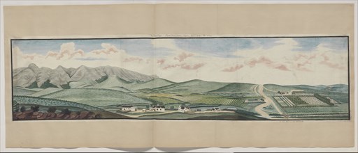
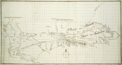
Panorama of Tulbagh, then known as the Land van Waveren in the Roodezand valley, 1778-1779. Creators: Robert Jacob Gordon, Johannes Schumacher.
HRM23A86_235

Panorama of Tulbagh, then known as the Land van Wa...
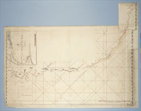
Map of the Coast from Saldanha Bay to Richard’s Bay, with a detailed map of Mossel..., c.1777-1778. Creators: Robert Jacob Gordon, Johannes Schumacher.
HRM23A86_223

Map of the Coast from Saldanha Bay to Richard’s Ba...
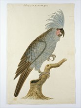
Palm cockatoo, in or after c.1780. Creators: Robert Jacob Gordon, Johannes Schumacher.
HRM23A86_232

Palm cockatoo, in or after c.1780. Creators: Rober...

Map of the Southern part of the Cape from St Helena Bay to the Great Fish River, c.1777-1786. Creators: Robert Jacob Gordon, Johannes Schumacher.
HRM23A86_222

Map of the Southern part of the Cape from St Helen...

Anthropoides paradisea (Blue crane or Stanley crane), 1777-1786. Creators: Robert Jacob Gordon, Johannes Schumacher.
HRM23A86_233

Anthropoides paradisea (Blue crane or Stanley cran...