même sujet
Hrmcartes12
Sujet
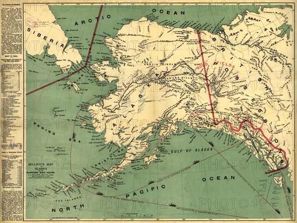
Millroy's map of Alaska and the Klondyke gold fields, 1897. Creator: J. J. Millroy.
Légende
Millroy's map of Alaska and the Klondyke gold fields, 1897. The Klondike Gold Rush of 1898 began in earnest within 18 months of a major gold strike on Bonanza Creek, a tributary of the Klondike River near Dawson City, Canada. A mapmaker from Salt Lake City, J.J. Millroy, created this guide to the Klondike gold fields in 1897 using government and private surveys. The map was intended for use by the many prospective miners who soon were to descend upon the Yukon from around the world. The map shows the major routes to the Klondike gold fields (in red), including the Chilkoot, Chilkat, Copper River, Yukon River, Taku River, and Stikine River Routes. The map also highlights major shipping routes and the exact mileage from San Francisco and Seattle to Juneau and to various other points in Alaska that provided the best access to the interior routes to the Klondike gold fields. The map also shows mountain ranges with elevations marked in feet, bodies of water, and significant towns and cities in Alaska and Canada.
Crédit
Photo12/Heritage Images/Heritage Art
Notre référence
HRM24A00_027
Model release
NA
Property release
NA
Licence
Droits gérés
Format disponible
92.5Mo (7.8Mo) / 55.4cm x 41.8cm / 6549 x 4936 (300dpi)