même sujet
Hrmcartes12
Sujet
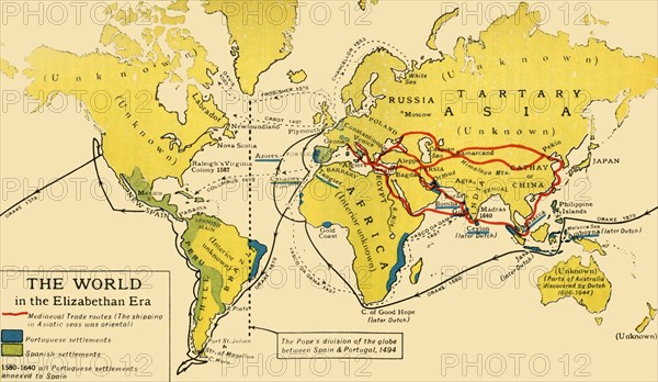
The World in the Elizabethan Era', 1926. s
Légende
'The World in the Elizabethan Era', 1926. Map of the world during the reign of Queen Elizabeth I (1558-1603). The key shows: 'Mediaeval Trade routes, (the shipping in Asiatic seas was oriental). Portuguese and Spanish settlements'. The dotted line from Greenland down through eastern Brazil represents the Pope's division of the globe between Spain and Portugal, 1494. Also marked are the voyages of Francis Drake, Vasco da Gama and Christopher Columbus. Many parts of the world remained 'unknown' at that period. From "History of England", by George Macaulay Trevelyan. [Longmans, Green and Co. Ltd, London, 1926]
Date
1926
Crédit
Photo12/Heritage Images/The Print Collector
Notre référence
HRM19F13_442
Model release
Non
Licence
Droits gérés
Format disponible
67.8Mo (2.1Mo) / 54.1cm x 31.4cm / 6387 x 3712 (300dpi)