Sujet
Section of the Map of Boston
Légende
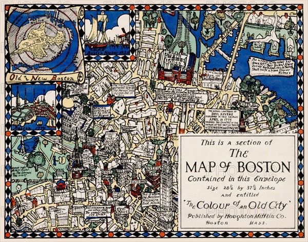
Boston pictorial map: Blake and Olsen’s 1926 “ Colour of an Old City. ” This map was the product of the collaboration of Blake Everett Clark (1900-1979) and Edwin Birger Olsen (1902-1996), two young American draftsmen & architects. Clark and Olsen’s Boston pictorial map includes the core of downtown, roughly from Massachusetts Avenue east, and encompasses the Charles River with parts of Cambridge and Charlestown, as well as the Harbor, Fort Point Channel (“South Bay”) and part of South Boston. The borders are embellished with vignettes depicting historic scenes, buildings and monuments. Boston’s coat of arms appears at top center, while six inset historical maps and views depict the city and its environs at different points in its history. Biplanes swarm above the Charles while numerous vessels ply the vibrantly-colored surrounding waters. Lyrical quotations praising the city dot the map, while an open book at lower center displays a ditty entitled “What It’s All About!” The map’s title appears on the sail of an incongruous Norse longboat floating above Albany Street… perhaps a homage to persistent theories that the Norse had visited the Charles River centuries before the arrival of the Puritans.
Date
1926
Crédit
Photo12/UIG/Universal History Archive
Notre référence
UMG22A48_399
Model release
Non
Property release
Non
Licence
Droits gérés
Format disponible
20.2Mo (1.9Mo) / 25.4cm x 20.0cm / 3000 x 2359 (300dpi)