Sujet
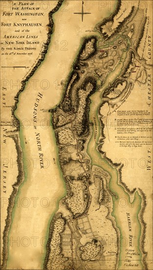
Hessian attack on Fort Washington under General Knypehausen on the 16th November 1776. 1776
Légende
A topographical map of the north. part of New York Island, exhibiting the plan of Fort Washington, now Fort Knypehausen, with the rebels lines to the southward, which were forced by the troops under the command of the Rt. Honble. Earl Percy on the 16th. November. 1776, and surveyed immediately after by order of His Lordship, by Claude Joseph Sauthier. To which is added the attack made to the north. by the Hessians, surveyed by order of Lieutenant. Genl. Knypehausen. Published by permission of the Rt. Honble. the Commissioners of Trade & Plantations.
Date
1776
Crédit
Photo12/Universal Images Group
Notre référence
UMG20A03_399
Model release
NA
Property release
NA
Licence
Droits gérés
Format disponible
33.2Mo (8.4Mo) / 21.8cm x 38.2cm / 2575 x 4513 (300dpi)