Sujet
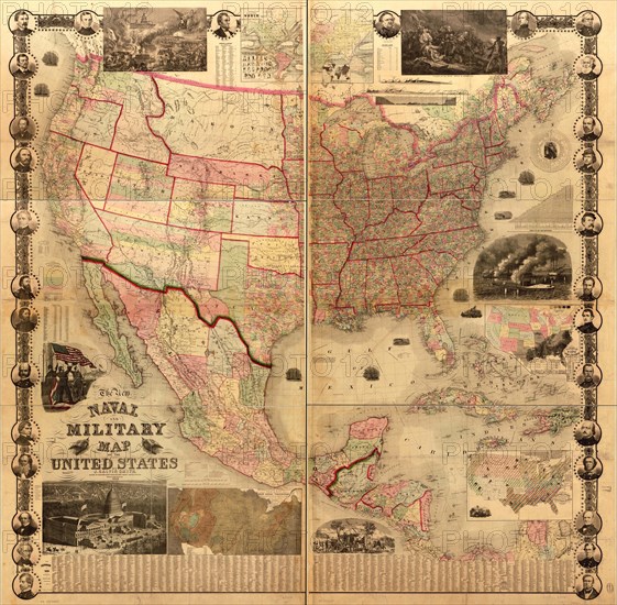
Naval Military Map of the United States 1862
Légende
naval and military map of the United States; General map of the United States, Mexico, and Central America showing national, state, and county boundaries, cities and towns, mail routes and wagon roads, railroads built and in progress, canals, and relief by hachures. The "date of organization of counties," ; Insets (maps): Map showing the fall of rain and mean annual temperature with the mountains, plains & river systems of the United States. 20 x 39 cm.-Map of the world on Mercator's projection [with an inset showing prevailing religions] 22 x 37 cm.-Map showing the distribution of the slave and free colored population of the United States. 21 x 28 cm.-Map showing the distribution of staples in colors with the principle articles of export marked in the states severally also the distribution of plants, trees, and animals; Decorative border includes the following portraits of prominent Union figures: President Lincoln, Messrs. Jos. Holt, G. G. Welles, S. P. Chase, and S. Cameron, Governor Sprague, Generals McClellan, Anderson, Sigel, Lyon, Lander, Dix, Pope, Fremont, Burnside, Banks, Scott, Wool, Halleck, Mansfield, McDowell, Blenker, Rosecrans, and Butler, Colonels Ellsworth and Corcoran, and Commodores Du Pont, Stringham, Wilkes and Foote.; Insets (views, some symbolic): The rescue of the Union. 19 x 31 cm.-Washington [city] 22 x 37.-Response of the army & navy. 21 x 20 cm.-The birth of the Union-battle of Bunker Hill. 19 x 31 cm.-Victory of the Monitor (2 guns) over the Merrimac (10 guns) March 9th 1862. 21 x 29 cm.-Scene of camp life
Date
1862
Crédit
Photo12/Universal Images Group
Notre référence
UMG20A03_099
Model release
NA
Property release
NA
Licence
Droits gérés
Format disponible
250.4Mo (26.0Mo) / 80.0cm x 78.4cm / 9449 x 9262 (300dpi)