Sujet
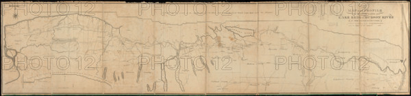
RECORD DATE NOT STATED A new map and profile of the proposed canal from Lake Erie to Hudson River in the state of New Yo
Légende
RECORD DATE NOT STATED A new map and profile of the proposed canal from Lake Erie to Hudson River in the state of New York. Includes 2 profiles: A profile of the extent of the levels and of the places and lifts of the locks between Lake Erie and the Hudson -- A profile of th the southern route west of the Genesee River. Includes chart of distances from Albany.. America Transformed: The Appalachian Mountains presented an obstacle for traffic flow from the Atlantic seaboard to the Midwest. After considering various projects to cross this barrier, the New York state government built the Erie Canal. Constructed from 1817 to 1825, the canal extended 363 miles connecting Albany on the Hudson River with Buffalo on Lake Erie. Taking advantage of a natural break in th Copyright: xpiemagsx levpiemap29122022-4525 ACHTUNG AUFNAHMEDATUM GESCHÄTZT
Info+
IMAGO/piemags
Date
01 janv. 1900
Crédit
Photo12/Imago
Notre référence
MGO25A11_312
Model release
Non
Licence
Droits gérés
Format disponible
226,8Mo (11,1Mo) / 155,3cm x 36,6cm / 18341 x 4323 (300dpi)