Légende
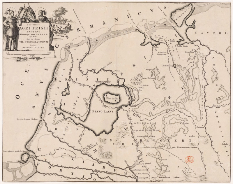
Descriptio agri Frisii Antiqui, Historical map of the Netherlands with the territories of the Batavians and Frisians, print, map, historical print, Map of the Frisian territories in the Roman period. Top left cartouche with title, surrounded by coats of arms and Frisian tribal leaders Verritus and Malorix depicted, warriors in the background. Scale bar below cartouche: Semis gradus., printmaker: Jan Luyken, Netherlands, writer (clerical worker): Menso Alting, 1697 - 1700, 1725, writer (clerical worker), paper, engraving, etching, height 329 mm x width 420 mm, Part of 16 maps of the land of the Batavians and the Frisians first produced for and included in Alting, Menso. Descriptio, secundum antiquos, agri Batavi & Frisii. 2 volumes. Amsterdam: Henricus Wetstein, 1697-1700. Reused in Halma, François. Tooneel der Vereenigde Nederlanden, en onderhorige landschaps, 2 volumes. Leeuwarden: Hendrik Halma, 1725. This map was used in Halma's Tooneel der Vereenigde Nederlanden (1725) and, according to the inscription at the top right, can be found in volume 2, p. 1b., maps of separate countries or regions, Roman period in the Netherlands, Batavians, Frisians, Friesland, A sepia-toned antique map showing coastlines, waterways, and inland features with intricate engraved shading and hachure. At the top left a decorative cartouche is flanked by two armored figures standing beside flags and helmets, and a small scene of seated and standing people near trees. The map area contains stylized lakes and an island with concentric shoreline shading, winding rivers, marshy or textured coastal bands, and irregular peninsulas. Small clusters of tree symbols and groups of tiny stick-like figures or tent shapes mark certain inland areas. Delicate dotted and dashed lines trace waterways and shores, while evenly spaced block letters are scattered across the map as labels. A round red stamped seal appears near the right center. The
Crédit
Photo12/Liszt Collection
Notre référence
LZT26B34_043
Licence
Droits gérés
Format disponible
58.5Mo (6.0Mo) / 43.1cm x 34.0cm / 5090 x 4019 (300dpi)