même sujet
Seismekanto12
Sujet
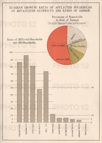
KANTO EARTHQUAKE 1923. Affected household ratio/Damage type Japan Tokyo 1926 map
Légende
'Diagram showing ratio of afflicted households in devastated districts and kinds of damage'. Artist/engraver/cartographer: The Bureau of Social Affairs Home Office, Japan. Provenance: "Companion maps and Diagrams to the great earthquake of 1923 in Japan"; Published by The Bureau of Social Affairs Home Office, Japan. Type: Vintage colour map.
Info+
Photographe : Antiqua Print Gallery
Date
1926
Crédit
Photo12/Alamy/Antiqua Print Gallery
Notre référence
LMY23T03_GJJA77
Utilisation
uniquement en France
Model release
Non
Property release
Non
Licence
Libre de droits
Format disponible
8.1Mo (272.0Ko) / 12.0cm x 16.9cm / 1417 x 1995 (300dpi)