Légende
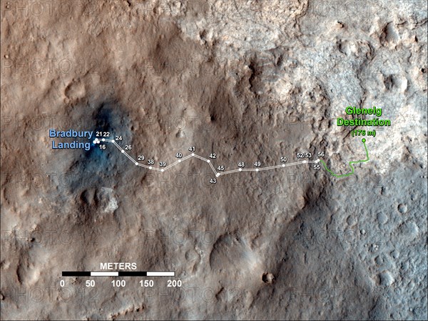
Curiosity's Travels Through Sol 56 This map shows the route driven by NASA's Mars rover Curiosity through the 56th Martian day, or sol, of the rover's mission on Mars (Oct. 2, 2012).
The route starts where the rover touched down, a site subsequently named Bradbury Landing. The white line extending toward the right (eastward) from Bradbury Landing is the rover's path so far, and the green line shows its planned future route. Numbering of the dots along the line indicate the sol number of each drive. North is up. The scale bar is 200 meters (656 feet). By Sol 56, Curiosity had driven at total distance of about 1,590 feet (484 meters).
The Glenelg area farther east is the mission's first major science destination, selected as likely to offer a good target for Curiosity's first analysis of powder collected by drilling into a rock.
The image used for the map is from an observation of the landing site by the High Resolution Imaging Science Experiment (HiRISE) instrument on NASA's Mars Reconnaissance Orbiter.
Info+
Photographe : NG Images
Crédit
Photo12/Alamy/NG Images
Notre référence
LMY22T03_CYCPRG
Utilisation
uniquement en France
Model release
Non
Property release
Non
Licence
Droits gérés
Format disponible
57.2Mo (4.1Mo) / 43.7cm x 32.8cm / 5163 x 3872 (300dpi)