même sujet
Ferdinand Magellan : une vie de découvertes
Sujet
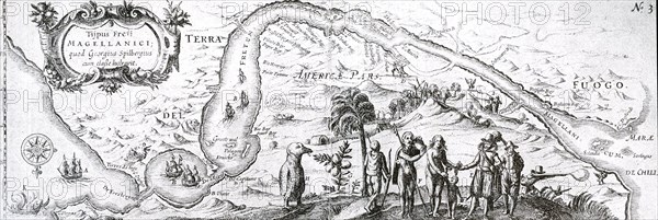
17th century Dutch East India Company map of the Strait of Magellan; a navigable sea route immediately south of mainland South America and north of Tierra del Fuego. Ferdinand Magellan (Portuguese: Fernão de Magalhães), a Portuguese sailor in the service of Charles I of Spain, became the first European to navigate the strait in 1520 during his global circumnavigation voyage.
Légende
17th century Dutch East India Company map of the Strait of Magellan; a navigable sea route immediately south of mainland South America and north of Tierra del Fuego. Ferdinand Magellan (Portuguese: Fernão de Magalhães), a Portuguese sailor in the service of Charles I of Spain, became the first European to navigate the strait in 1520 during his global circumnavigation voyage.
Info+
Photographe : World History Archive
Crédit
Photo12/Alamy/World History Archive
Notre référence
LMY20T04_D98N9P
Utilisation
uniquement en France
Model release
Non
Property release
Non
Licence
Droits gérés
Format disponible
32.8Mo (4.1Mo) / 49.5cm x 16.6cm / 5841 x 1960 (300dpi)