Sujet
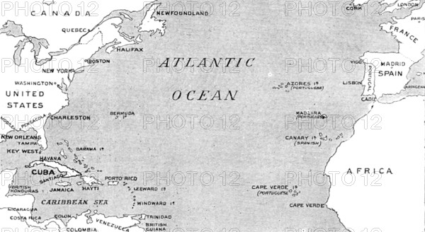
The Spanish-American War: map illustrating the relative positions of the two countries, 1898. Creator: Unknown.
Légende
The Spanish-American War: map illustrating the relative positions of the two countries, 1898. 'The long-expected has come at last, and war has been declared. On April 20 the United States Government at Washington performed the decisive act of committing itself to active hostilities...President McKinley signed the joint resolutions passed by the Senate and the House of representatives in Congress, and the ultimatum demanding that the Spanish Government should, before noon on Saturday, consent to relinquish its authority in Cuba, and to withdraw its military and naval forces from the island. A copy of this ultimatum was instantly sent to the Spanish Ambassador, Señor Polo de Bernabe, and a telegram of its purport to General Woodford, the American Minister at Madrid, to be communicated immediately to the Government of the Queen-Regent of Spain, which was done in the course of the afternoon. Señor Polo de Bernabe...departed in the evening for Canada. General Woodford, at Madrid, early the next day received a note from the Spanish Minister of Foreign Affairs to the effect that diplomatic intercourse was broken off, whereupon he set forth on his journey into France, escorted at starting by a troop of the Civil Guards.' From "Illustrated London News", 1898.
Crédit
Photo12/Heritage Images/The Print Collector
Notre référence
HRM26A15_277
Model release
NA
Property release
NA
Licence
Droits gérés
Format disponible
8.7Mo (842.8Ko) / 20.0cm x 10.9cm / 2360 x 1292 (300dpi)