Sujet
The French in West Africa: map with shaded portion denoting the sphere of British influence, 1898. Creator: Carl Hentschel.
Légende
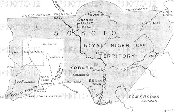
The French in West Africa: map with shaded portion denoting the sphere of British influence, 1898. 'Anglo-French Frontier Agreement 1890; Royal Niger Company's territory; the Gold Coast - Cape Coast Castle, Akra (Accra); Togoland - German; Dahomey - French; Yoruba; Lokoja; Benin; River Niger; Cameroons - German. Much excitement has prevailed since the news...of French subaltern officers in command of detachments of negro soldiery pursuing a course of aggressive movements within the British territories of the interior, chiefly in the Borgu and Gambara countries to the north of Lagos, but also in the "Hinterland" or back country north of Ashanti and the Gold Coast, and even in the large native kingdom of Sokoto, beyond the left bank of the Niger, extending towards Lake Tchad. Lagos, which is by far the most important British commercial colony in West Africa, situated in the middle of the great Bight of Benin, and commanding to the eastward all the mouths or outlets of the Niger that give access to the interior, possesses a hinterland well defined by the international treaty of 1890, with a frontier separating it from the French territory...including the Yoruba, Ilorin, Gambara, and Borgu native kingdoms subordinate to British supreme rule'. From "Illustrated London News", 1898.
Crédit
Photo12/Heritage Images/The Print Collector
Notre référence
HRM26A14_488
Model release
NA
Property release
NA
Licence
Droits gérés
Format disponible
10.1Mo (966.4Ko) / 19.7cm x 12.8cm / 2331 x 1511 (300dpi)