Sujet
Map showing the Great Forest traversed by Mr. Stanley and his party, 1890. Creator: Unknown.
Légende
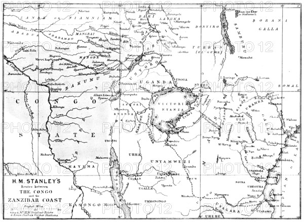
Map showing the Great Forest traversed by Mr. Stanley and his party, 1890. 'H.M. Stanley's Routes between the Congo and the Zanzibar Coast [showing Emin Pasha's former stations.] On the Monday evening, at the Royal Albert Hall, which had been engaged for the meeting of the Royal Geographical Society, the vast building was filled by more than seven thousand persons...Overhead, in front of the organ, was stretched an enormous map delineating Central Africa, from the Atlantic to the Indian Ocean, and conspicuously marked by a large green patch, indicating the great forest of which Mr. Stanley has given such graphic descriptions. The President's address, introducing Mr. Stanley, was brief and to the point, and the latter, on rising, was enthusiastically applauded. His romantic descriptions of the great Forest of the Congo (as it is called on the map), of the Mombuttu race of pigmies, of the Albert Edward Nyanza, and of the Ruwenzori mountain range, with references to Homer, Herodotus, and the ancient Greek and Arab geographers, were the chief features of the lecture, which lasted about an hour'. From "Illustrated London News", 1890.
Crédit
Photo12/Heritage Images/The Print Collector
Notre référence
HRM25A57_327
Model release
NA
Property release
NA
Licence
Droits gérés
Format disponible
32.0Mo (2.1Mo) / 33.1cm x 24.2cm / 3907 x 2860 (300dpi)