Sujet
Map of the Balloon Voyage from Hastings to Boulogne, 1883. Creator: Unknown.
Légende
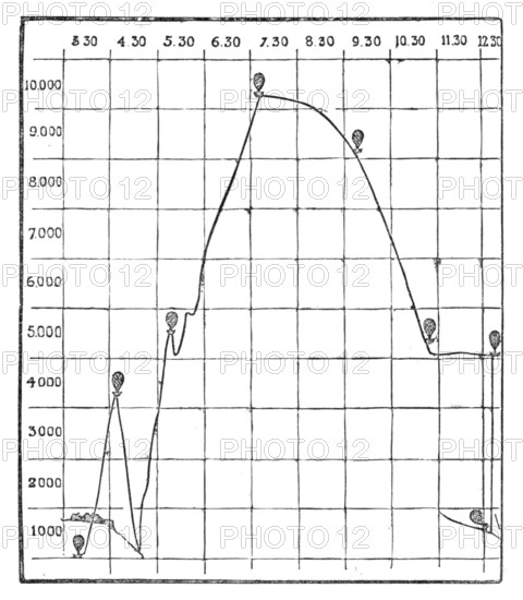
Map of the Balloon Voyage from Hastings to Boulogne, 1883. 'The Plan represents the altitudes that were reached, in the course of Mr. Simmons' balloon voyage, accompanied by Mr. C. S. Smale, photographer, from Hastings to the French coast at Cape La Hogue [the extreme north-west point of Normandy], near Cherbourg, on Thursday, the 15th September, when they ascended at three o'clock in the afternoon, and came down half an hour after midnight...The balloon travelled nearly a hundred and fifty miles in a south-west direction from Hastings. It rose at first to a height of between 4000 ft. and 5000 ft., directly over Hastings, as is shown in our Plan by the little sketch of Hastings Castle...They very gradually parted with their ballast, to prevent the balloon coming in the sea from the condensation of the gas...they heard the surf breaking upon this coast beneath them, and passed swiftly across it, throwing out their grappling iron, which, fortunately, caught hold of the rocks..., giving them just room to descend on the beach. Had the "Colonel," as this balloon is named, gone on for half a second, ten yards farther, they would have fallen into the sea...next morning they made their way to Cherbourg, and so got home to England in safety'. From "Illustrated London News", 1883.
Crédit
Photo12/Heritage Images/The Print Collector
Notre référence
HRM25A50_202
Model release
NA
Property release
NA
Licence
Droits gérés
Format disponible
5.7Mo (223.7Ko) / 46.5cm x 53.2cm / 1317 x 1508 (72dpi)