Sujet
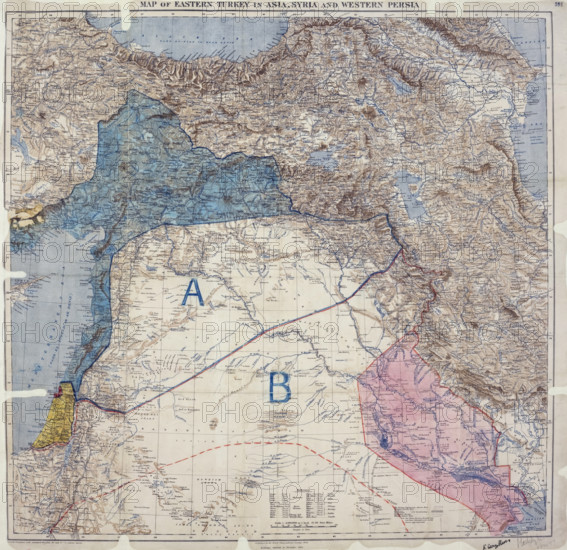
Map showing Eastern Turkey in Asia, Syria and Western Persia, and areas of control and...1916. Creator: Unknown.
Légende
Map of Eastern Turkey in Asia, Syria and Western Persia, 8 May 1916. Map showing areas of control and influence agreed upon between the British and the French. 1 item (enclosure in Paul Cambon's letter to Sir Edward Grey, 9 May 1916) showing mountains, defiles, rivers, lakes, swamps, seas, wadis, ancient canals (dry), the Jordan Depression, towns, villages, castles, bridges, principal routes, railways, telegraph lines, and boundaries, including the approximate boundary between Persian and Turkish territory; (covering territory now chiefly in Iran, Iraq, Syria and Turkey). Reference tables; list of place name elements. Conical projection with standard parallels at approximately 32° and 40°[E]. Published by the Royal Geographical Society, 1910; railways added to November 1915. MS additions, coloured, showing proposed administration, including independent Arab States, and the 'Sykes-Picot Line'. Signed by Sir Mark Sykes and François Georges-Picot, 8 May 1916.
Crédit
Photo12/Heritage Images/Heritage Art
Notre référence
HRM25A46_483
Model release
NA
Property release
NA
Licence
Droits gérés
Format disponible
68.3Mo (12.7Mo) / 42.0cm x 40.8cm / 4960 x 4815 (300dpi)