Sujet
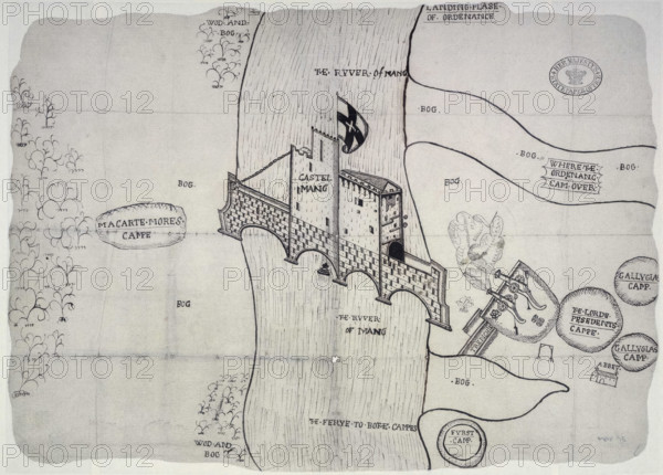
Plan depicting the siege by Sir John Perot, Lord President of Munster, County Kerry Castlemaine,1572 Creator: Unknown.
Légende
Plan depicting the siege by Sir John Perot, Lord President of Munster, County Kerry Castlemaine, 1572. Places marked include 'Wod and bog, ferye to bothe campes, the river of Mang, Macarte Mores campe, Castel Mang, abbey, trenchis, Gallyglas camp, landing plase of ordenance' and 'where the ordenanc cam over'. Castlemaine, (Irish: Caisleán na Mainge, meaning 'castle of An Mhaing/River Maine') built in 1215, stood on a bridge over the River Maine in County Kerry, Ireland.
Crédit
Photo12/Heritage Images/Heritage Art
Notre référence
HRM25A46_482
Model release
NA
Property release
NA
Licence
Droits gérés
Format disponible
50.5Mo (6.6Mo) / 42.0cm x 30.1cm / 4960 x 3558 (300dpi)