Sujet
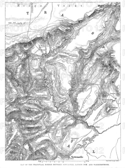
Map of the Transvaal border between Newcastle, Laing's Nek and Wakkerstroom, 1881. Creator: Stanford's Geographical Establishment.
Légende
Map of the Transvaal border between Newcastle, Laing's Nek and Wakkerstroom, 1881. 'A portion of the rugged highlands on the borders of Natal and the Transvaal country, where the British forces under Sir George Colley and Sir Evelyn Wood have to encounter the opposing Boers, under Commandant Franz Joubert, in the renewed advance this week, is delineated in our Map. The starting-point of their advance is the town of Newcastle, in Natal, the British headquarters for this campaign; and the immediate object is to force a passage to the Hooge Veldt or high open plain of the Transvaal, a sort of table-land, which is indicated at the top of the Map. The situation of Newcastle, about thirty miles distant in a straight line, as the crow flies, is seen at the bottom...On the 8th Feb., Colley was attacked on both flanks, and in his front, by...combined parties of the Boers, while on his road to reopen the communications between his camp and Newcastle. This conflict took place on the elongated hill, clearly shown..., one extremity of which is called Schain's Hooghte, and which extends between the Imbazane and Ingogo rivers...over the hills to Wakkerstroom...is the second or alternative route to get up to the Hooge Veldt or elevated open plain'. From "Illustrated London News", 1881.
Crédit
Photo12/Heritage Images/The Print Collector
Notre référence
HRM25A43_110
Model release
NA
Property release
NA
Licence
Droits gérés
Format disponible
32.4Mo (3.7Mo) / 24.6cm x 33.0cm / 2907 x 3901 (300dpi)