Sujet
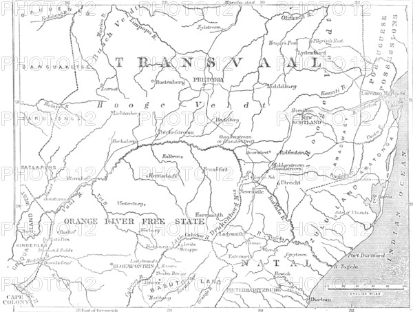
Map of the Transvaal and adjacent provinces, 1881. Creator: Stanford's Geographical Establishment.
Légende
Map of the Transvaal and adjacent provinces, 1881. The British in South Africa. 'If now, therefore, her Majesty's Government should feel called upon, returning to the honourable observance of that Convention, to re-establish the Transvaal Republic, it will be only just and right to cut off all those outlying dominions, gained by unjustifiable Dutch encroachments, and reduce their future realm to its original extent. The Map shows, in its northward limit, something like the utmost verge and scope of a fair arrangement to this purpose. It happens that Nature has provided a most convenient boundary, in the Waterberg and several other ranges, stretching all across the Transvaal region from west to east, from the Marico to the Lydenburg districts, to shut off the principal native tribes from the Dutch commonwealth. The Bush country beyond has proved insalubrious to man and beast, and the Boers can do very well without it. At any rate, we do not think they will ever get it with the goodwill of the British Government, which is pledged to stop further aggression upon the native tribes; though it has, with singular inconsistency, made war on Cetewayo for resisting these encroachments on the Pongola and in the Utrecht district'. From Illustrated London News", 1881.
Crédit
Photo12/Heritage Images/The Print Collector
Notre référence
HRM25A43_071
Model release
NA
Property release
NA
Licence
Droits gérés
Format disponible
29.2Mo (903.9Ko) / 31.1cm x 23.5cm / 3671 x 2777 (300dpi)