Sujet
Subsidence of land at the Northwich Salt-Mines, 1881. Creator: Unknown.
Légende
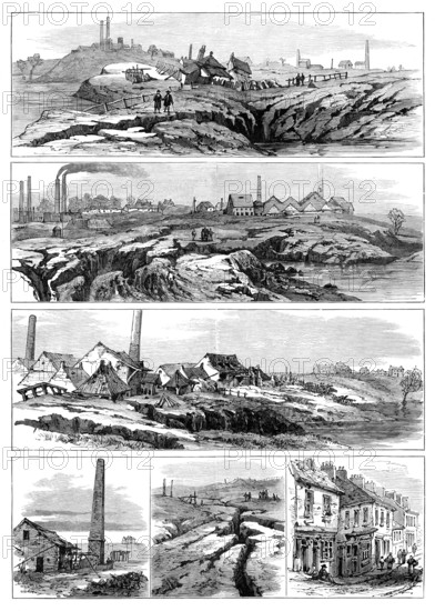
Subsidence of land at the Northwich Salt-Mines, 1881. '...remarkable disturbances in the surface of the land...Platt's Hill rock-salt mine, fifty acres in extent, is submerged, and can never again be worked as a rock-salt mine. Fears are entertained that several other rock-salt mines in the neighbourhood will be inundated...Another great chasm has opened across the roadway close to Messrs. N. Ashton and Son's salt-works...Great rifts and clearings and the bodily dropping of the surface by slips make it appear as if an earthquake had occurred, accompanied by volcanic action, the surface being loaded with mud from the geyser-like action before subsidence. Should the flooding extend to Messrs. Fletcher's mine, which is said to be the largest in the world, very serious consequences would ensue, as this mine extends a very great distance under extremely populous districts surrounding Northwich...The Sketches shown in our page of Engravings were taken by our own Artist at the Witton and Dunkirk Salt-works of Messrs. N. Ashton and Sons, and at the Platt's Hill Saltworks of Mr. John Thompson. Witton is the name of the largest quarter of Northwich, and Dunkirk is part of Witton'. From "Illustrated London News", 1881.
Crédit
Photo12/Heritage Images/The Print Collector
Notre référence
HRM25A42_386
Model release
NA
Property release
NA
Licence
Droits gérés
Format disponible
50.6Mo (5.3Mo) / 30.1cm x 42.2cm / 3550 x 4979 (300dpi)