Sujet
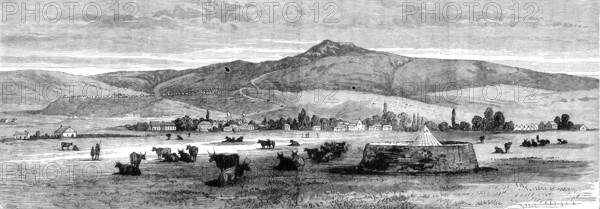
The Transvaal War: view of Newcastle from Fort Terror, 1881. Creator: Unknown.
Légende
The Transvaal War: view of Newcastle from Fort Terror, 1881. '...a view of the town of Newcastle, in Natal, which is twenty-four miles from Laing's Neck, the road northward to the place last mentioned being across the Ingogo valley, over the long range of hills called Schain's Hoogte, and then by Mount Prospect, where Sir George Colley fixed his advanced camp, within four miles of the Boers' defensive position...The view of Newcastle, as will be seen by the flags displayed over the military headquarters in the town, by the tents of the encampment on the neighbouring hill, around Fort Amiel, and on the plain to the right hand, as well as by the circular redoubts or "forts," erected at several points, was sketched at the time of fullest preparation for continued hostilities. One of these little "forts," bearing the name of "Terror," and designed for the protection of the town against a possible attack after the second disastrous conflict with the Boers, was the point of view from which the Sketch was taken. The eminence rising in the background is the "hill above Fort Amiel," where the heliograph station used to communicate by signals with the camp at Mount Prospect'. From "Illustrated London News", 1881.
Crédit
Photo12/Heritage Images/The Print Collector
Notre référence
HRM25A42_371
Model release
NA
Property release
NA
Licence
Droits gérés
Format disponible
24.7Mo (3.2Mo) / 42.1cm x 14.7cm / 4970 x 1736 (300dpi)