Sujet
Seven Years War (1756-1763): Map of the Battle of Warburg (July 31, 1760), 1765. Creator: Jean de Beaurain.
Légende
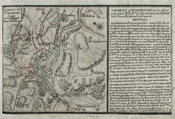
Seven Years War (1756-1763): Map of the Battle of Warburg (July 31, 1760), 1765. Between the Allied British and Hanoverian army, led by Field Marshal Prince Ferdinand of Brunswick-Wolfenbüttel (1721-1792), and the French army, commanded by Lieutenant-General Le Chevalier du Muy (Louis Nicolas Victor de Felix d'Ollieres). Allied victory. Published in 1765 by the cartographer Jean de Beaurain (1696-1771) as an illustration of his "Great Map of Germany, with the events that took place during the Seven Years War". Allied army in red and the French army in blue. French edition, 1765.
Crédit
Photo12/Heritage Images/PRISMA ARCHIVO FOTOGRÁFICO, S.L.
Notre référence
HRM25A41_050
Model release
NA
Property release
NA
Licence
Droits gérés
Format disponible
47.9Mo (4.4Mo) / 42.0cm x 28.6cm / 4961 x 3378 (300dpi)