Sujet
Seven Years War (1756-1763): Map of the Battle of Vellinghausen (July 15-16, 1761), 1765. Creator: Jean de Beaurain.
Légende
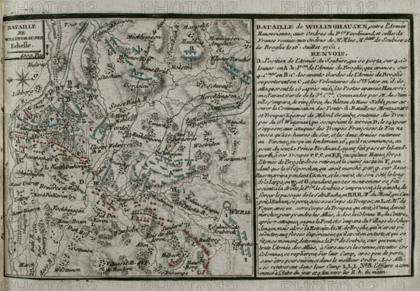
Seven Years War (1756-1763): Map of the Battle of Vellinghausen (July 15-16, 1761), 1765. It took place on the banks of the Lippe River in North West Germany. Confronted the allied Prussian-Hanoverian-British army led by Prince Ferdinand of Brunswick against the French army under the command of the Duc de Broglie and the Prince Soubise. The French force had to retreat. Published in 1765 by the cartographer Jean de Beaurain (1696-1771) as an illustration of his "Great Map of Germany, with the events that took place during the Seven Years War". Allied army in red and the French army in blue. French edition, 1765.
Crédit
Photo12/Heritage Images/PRISMA ARCHIVO FOTOGRÁFICO, S.L.
Notre référence
HRM25A41_049
Model release
NA
Property release
NA
Licence
Droits gérés
Format disponible
44.3Mo (3.7Mo) / 40.0cm x 27.7cm / 4724 x 3277 (300dpi)