Sujet
Seven Years War (1756-1763): Pomeranian War - Map of Stralsund - blockade of Stralsund..., 1765. Creator: Jean de Beaurain.
Légende
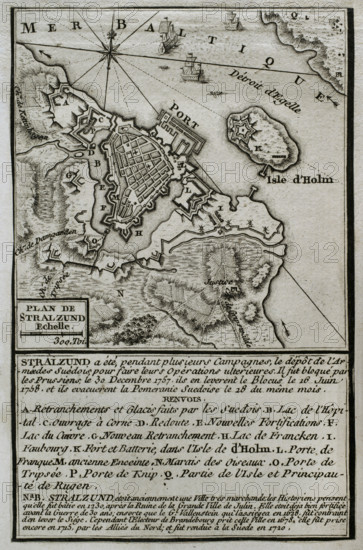
Seven Years War (1756-1763): Pomeranian War - Map of Stralsund - blockade of Stralsund (30th December, 1757 to 16th June, 1758), 1765. Blockade of Stralsund (30th December, 1757 to 16th June, 1758). Prussian troops surrounded the Swedish garrison of Stralsund (capital of Swedish Pomerania). The Prussians could not isolate the town by sea because they lacked a fleet, but they cut-off and blockaded it by land on December 30, 1757. Finally the blockade was raised on 16th June 1758 when mainly of the Prussian forces were withdrawn to reinforce military actions elsewhere. Published in 1765 by the cartographer Jean de Beaurain (1696-1771) as an illustration of his "Great Map of Germany, with the events that took place during the Seven Years War". French edition, 1765.
Crédit
Photo12/Heritage Images/PRISMA ARCHIVO FOTOGRÁFICO, S.L.
Notre référence
HRM25A41_045
Model release
NA
Property release
NA
Licence
Droits gérés
Format disponible
49.1Mo (4.5Mo) / 28.5cm x 43.2cm / 3366 x 5103 (300dpi)