Sujet
Plan of the Battle of Sandershausen, Germany (July 23, 1758), 1765. Creator: Jean de Beaurain.
Légende
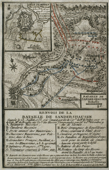
Plan of the Battle of Sandershausen, Germany (July 23, 1758), 1765. Published in 1765 by the cartographer Jean de Beaurain (1696-1771) as an illustration of his "Great Map of Germany, with the events that took place during the War of the Seven Years". War from 1755 to 1763. Allied army in red and the French army in blue. French edition, 1765.
Crédit
Photo12/Heritage Images/PRISMA ARCHIVO FOTOGRÁFICO, S.L.
Notre référence
HRM25A41_043
Model release
NA
Property release
NA
Licence
Droits gérés
Format disponible
46.9Mo (4.5Mo) / 27.5cm x 42.7cm / 3253 x 5043 (300dpi)