Sujet
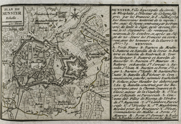
Seven Years War (1756-1763): Plan of Münster, 1759 (Germany), 1765. Creator: Jean de Beaurain.
Légende
Seven Years War (1756-1763): Plan of Münster, 1759 (Germany), 1765. Episcopal city of the imperial circle of Westphalia. It was taken by the French on 8 July 1759. The Hanoverians tried to retake Munster, but on 15 September the French succeeded in lifting the siege of the town. The Hanoverians returned again on 30 October, and after a 20-day siege, the French had to abandon it, leaving with the honours of war on 21 November 1759. Published in 1765 by the cartographer Jean de Beaurain (1696-1771) as an illustration of his "Great Map of Germany, with the events that took place during the Seven Years War". French edition, 1765.
Crédit
Photo12/Heritage Images/PRISMA ARCHIVO FOTOGRÁFICO, S.L.
Notre référence
HRM25A41_033
Model release
NA
Property release
NA
Licence
Droits gérés
Format disponible
46.2Mo (4.0Mo) / 41.0cm x 28.2cm / 4843 x 3334 (300dpi)