Sujet
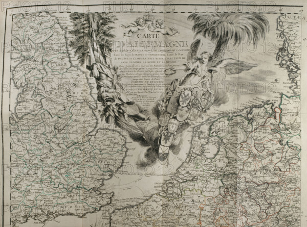
Map of Germany showing war of 1755 to 1763 (Seven Years War), 1765. Creator: Jean de Beaurain.
Légende
Map of Germany showing war of 1755 to 1763 (1765). 'Carte d'Allemagne pour server à l'intelligence de l'histoire de la guerre entre les Roys de France et d'Angleterre; entre le Roy de Prusse et l'Impératrice Reine, l'Electeur de Saxe, l'Empire, La Suede, et La Russie. Dans laquelle on a marqué les Batailles, Combats, prises de Villes, et Camps qu'on a puy faire entrer. On y a trace les Routes publiques et joint une Histoire abrégé des principaux faits Militaires arrives tant sur Terre que sur Mer, jusqu'aux Traités de Paix, Enrichié et Entourée de 74 Plans représantant les evènements les plus mémorables arrives pendant le Cours de la Guerre, Com.ée en 1755, finié en 1763...(Map of Germany...war between the Kings of France and England; the King of Prussia and the Empress Queen, the Elector of Saxony, the Empire, Sweden, and Russia...[with an] abridged History of the principal Military facts occurring both on Land and Sea, up to the Peace Treaties, Enriched and Surrounded by 74 Plans representing the most memorable events occurring during the Course of the War...). Published by the cartographer Jean de Beaurain in his "Great Map of Germany, with the events that took place during the War of the Seven Years". Allied army in red and the French army in blue. French edition, 1765.
Crédit
Photo12/Heritage Images/PRISMA ARCHIVO FOTOGRÁFICO, S.L.
Notre référence
HRM25A41_003
Model release
NA
Property release
NA
Licence
Droits gérés
Format disponible
47.4Mo (4.3Mo) / 40.0cm x 29.7cm / 4724 x 3506 (300dpi)