Sujet
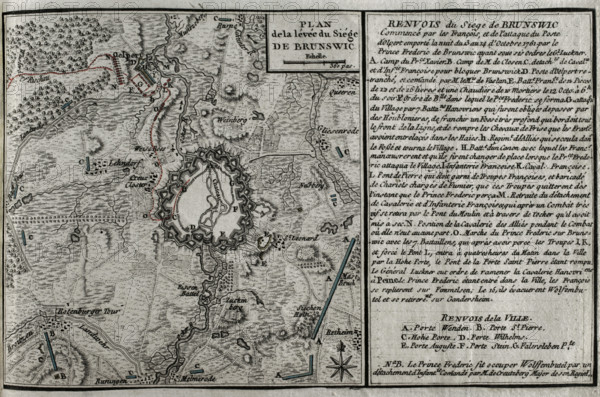
Seven Years War (1756-1763): Map of the rising of the Siege of Brunswick, 1761 (1765). Creator: Jean de Beaurain.
Légende
Seven Years War (1756-1763): Map of the rising of the Siege of Brunswick, 1761 (1765). Brunswick was besieged by the French after the Battle of Olper (13 October 1761) in which the Franco-Saxon army confronted Brunswick-Hanoverian force, under the command of Frederick Augustus of Braunschweig-Wolfenbüttel, Prince of Brunswick-Wolfenbuttel-Oels. The French attack, led by François-Xavier de Saxe, Count of Lusatia, was held on the night of 13-14 October 1761, being defeated by the Brunswick army of Frederick William and General Luckner. Published in 1765 by the cartographer Jean de Beaurain (1696-1771) as an illustration of his "Great Map of Germany, with the events that took place during the Seven Years War". Allied army in red and the French army in blue. French edition, 1765.
Crédit
Photo12/Heritage Images/PRISMA ARCHIVO FOTOGRÁFICO, S.L.
Notre référence
HRM25A40_499
Model release
NA
Property release
NA
Licence
Droits gérés
Format disponible
43.3Mo (2.7Mo) / 40.5cm x 26.8cm / 4781 x 3168 (300dpi)