Sujet
Map of the Strait of Malacca, 1874. Creator: Unknown.
Légende
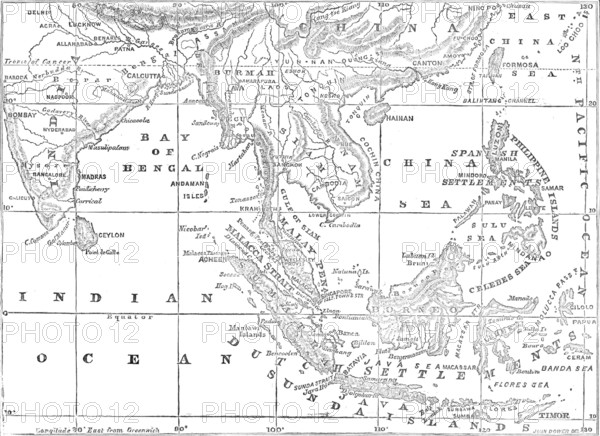
Map of the Strait of Malacca, 1874. 'The Dutch Government is now engaged in a warfare against the Sultan of Acheen [Aceh], which is a Mohammedan Malay State at the northern extremity of the large Isle of Sumatra...The Strait of Malacca...is the maritime passage between the Malay Peninsula and the Island of Sumatra...The greater portion of the island shores opposite to Malacca does not belong to Acheen, but to several petty States...The Dutch possessions in Sumatra...[consist] of the five regencies of Palembang, Lampong, Bencoolen, Padang, and Ayer Banghis, including the port of Baroos. Since the beginning of the seventeenth century there has been a rivalry between the Dutch and English for trade, and sometimes for dominion, in this part of the world...The three British settlements on the mainland shore...are of great value to us, especially that of Singapore...The Dutch settlement of Malacca was ceded to Great Britain in 1824...The aggregate value of yearly exports and imports at the three British settlements in the Strait of Malacca is nearly twenty-two millions sterling, and the aggregate tonnage of vessels arriving there exceeds a million tons' burden in the year. The Strait of Malacca is also the way for our maritime commerce to China. From "Illustrated London News", 1874.
Crédit
Photo12/Heritage Images/The Print Collector
Notre référence
HRM25A32_290
Model release
NA
Property release
NA
Licence
Droits gérés
Format disponible
28.3Mo (1.1Mo) / 31.2cm x 22.7cm / 3688 x 2686 (300dpi)