Légende
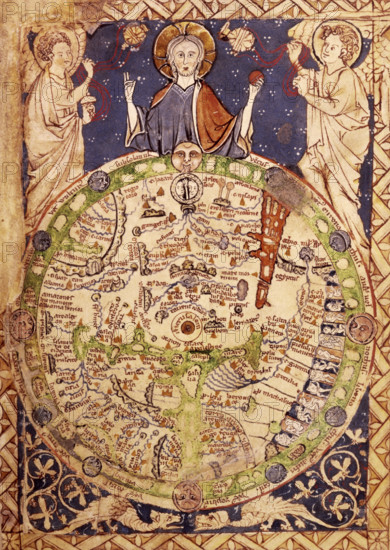
Psalter Map, c1250. A round map of the world, set in a square ornamental frame, Jerusalem being in the centre, with a zone of winds, figures of inhabitants, etc. The Psalter map is so called because it accompanied a 13th Century copy of the Book of Psalms. It is one of the earliest maps with Jerusalem at the centre, reflecting the medieval world view. Although tiny, it contains a wealth of information. It is the earliest surviving map to symbolise Christ's power as overseer of the world; and one of the earliest maps to depict Biblical events - for example, Moses crossing the Red Sea (the large red expanse, top right); and the earliest to display the `monstrous' races in Africa (the strange figures, some without heads, depicted on the right-hand edge). From Latin Psalter, with canticles, litany, etc. latin-psalter-with-canticles-litany-etc----caption-a-round-map-of-the-world-set-in-a-square-ornamental-frame-jerusalem-being-in-the-centre-with-a-zone-of-winds-figures-of-inhabitants-etc-_12458916815
Date
1250
Crédit
Photo12/Heritage Images/Heritage Art
Notre référence
HRM25A16_286
Model release
NA
Property release
NA
Licence
Droits gérés
Format disponible
50.6Mo (4.6Mo) / 30.0cm x 42.3cm / 3543 x 4993 (300dpi)