Sujet
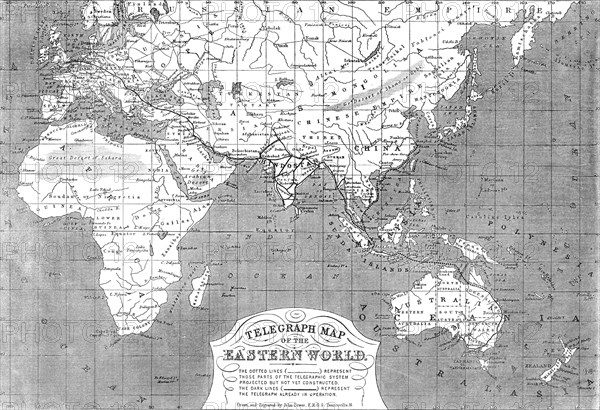
Telegraph map of the Eastern World, 1865. Creator: John Dower.
Légende
Telegraph map of the Eastern World, 1865. Map showing '...the progress of telegraphic communication from England in the directions of India, China, and the British colonies...It is owing to the immense growth of English commerce and colonisation in those distant regions, as well as to the political and military exigencies of our Indian empire, since the government of the East India Company was superseded by the direct rule of Queen Victoria after the suppression of the revolt of 1857, that the necessity for a speedy transmission of messages between London and the remotest of the British provinces in the East has led to the stupendous conception of a telegraphic system embracing half the circumference of the earth...our telegraphic communications with the Eastern world...[are soon] to be extended to China...From Rangoon, in the Burmese provinces of our Indian empire, to the great commercial port of Singapore, a cable will be laid, at no great distance from the coast of the Malayan Peninsula...along the eastern coast of Asia, to Hong-Kong and Shanghai...The dotted lines represent those parts of the telegraphic system...not yet constructed. The dark lines represent the telegraph already in operation'. From "Illustrated London News", 1865.
Crédit
Photo12/Heritage Images/The Print Collector
Notre référence
HRM24A26_180
Model release
NA
Property release
NA
Licence
Droits gérés
Format disponible
56.2Mo (5.5Mo) / 45.3cm x 31.0cm / 5356 x 3666 (300dpi)