Sujet
Map of Baikal, a Sea, a Lake, or an Angara Gap, Located in the Irkutsk Province..., 1814. Creator: Unknown.
Légende
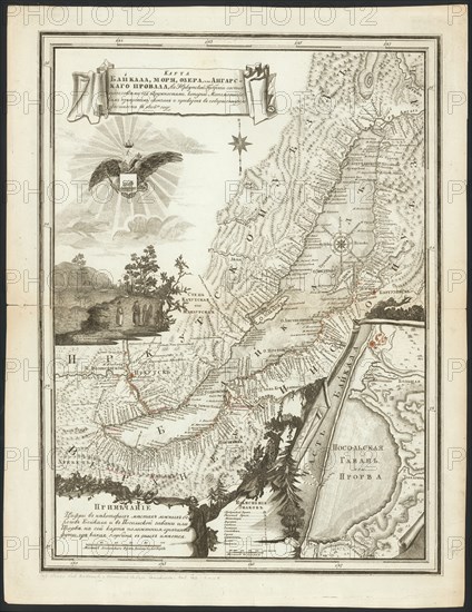
Map of Baikal, a Sea, a Lake, or an Angara Gap, Located in the Irkutsk Province with All the Neighboring [Territory], Whose Mathematical Measurements were Completed and it Became Fully Known in 1806, 1814. Lake Baikal and the region around it were extensively explored by Russian expeditions in the late 18th and early 19th centuries. This map shows in great detail the shoreline of the lake and the network of rivers flowing into and out of Baikal. The title of the map is shown in a cartouche. Below the title is a single-headed eagle, holding in its talons the coat of arms of Irkutsk Province. The illustration at the lower left is a view of Nikolaevsk Pier, located at the point where the Angara River flows from the lake. The enlarged map in the lower right-hand corner depicts Ambassador's Harbor or "Prorva." The numbers indicate soundings of depth in feet. The map uses perspective to show hills and mountains. Lake Baikal is the deepest lake in the world. Its volume of water is approximately equal to the total volume of the Great Lakes of North America, or to about 20 per cent of all freshwater on the earth.
Crédit
Photo12/Heritage Images/Heritage Art
Notre référence
HRM24A00_116
Model release
NA
Property release
NA
Licence
Droits gérés
Format disponible
78.9Mo (6.3Mo) / 39.1cm x 50.6cm / 4614 x 5980 (300dpi)