Sujet
Western motor car route guide, (1915?). Creator: Unknown.
Légende
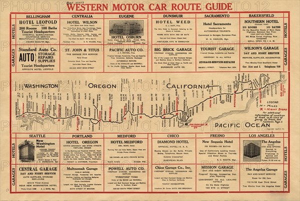
Western motor car route guide, (1915?). This automobile guide shows the main highway route between Vancouver, Canada, and San Diego, California, circa 1915. The map lists the distance in miles from Vancouver to cities along the way, and highlights in red lettering the major intermediate stops, such as Seattle, Portland, San Francisco (Oakland), Bakersfield, and Los Angeles. Major civic expositions occurring in San Francisco and San Diego in 1915, which stimulated significant motor travel that year, are noted in red as well. Parts of the route include the Pacific Highway as well as follow segments of the Spanish-era El Camino Real (The Royal Road), but much of the route takes a more inland course, traversing the Willamette Valley of Oregon and the Central Valley of California. Side roads to Bend, Oregon; Stockton, California; and the Mojave Desert are shown branching off the main route. The map also marks approximate state boundaries for Washington, Oregon, and California, and it suggests places for overnight stops. Advertisements for local hotels and garages are included along the margins, placed for ease of use adjacent to each major city on the map. The populations of selected cities and towns are listed.
Crédit
Photo12/Heritage Images/Heritage Art
Notre référence
HRM24A00_105
Model release
NA
Property release
NA
Licence
Droits gérés
Format disponible
51.0Mo (3.9Mo) / 43.6cm x 29.3cm / 5147 x 3461 (300dpi)