Sujet
The Russian discoveries from the map published by the Imperial Academy of St. Petersburg, 1775. Creator: Unknown.
Légende
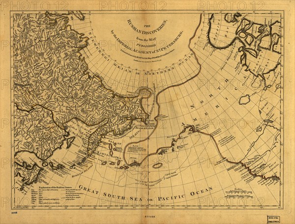
The Russian discoveries from the map published by the Imperial Academy of St. Petersburg, 1775. This map, showing the known geography of Alaska in the late 18th century, was based on an original Russian map by Gerhard Friedrich Mu¨ller published in 1754 by the Imperial Academy of Saint Petersburg. The map was printed in 1775 on Fleet Street in London by Robert Sayer, a noted English map and print seller. Because the North Pacific and Arctic constituted the last largely unknown parts of the world at this time, early maps of Alaska were popular in Western Europe and were frequently reprinted. The map was published before the third Pacific voyage of Captain Cook to Alaska in 1778, and thus is still based on bearings and other geographical information obtained from the twin voyages of Vitus Bering and Aleksei Chirikov (shown by dotted lines) to Alaska in 1741, as well as on the findings of even earlier Russian expeditions.
Crédit
Photo12/Heritage Images/Heritage Art
Notre référence
HRM24A00_104
Model release
NA
Property release
NA
Licence
Droits gérés
Format disponible
135.1Mo (10.6Mo) / 66.6cm x 50.8cm / 7870 x 6002 (300dpi)