Sujet
Reduced map of Russian discoveries, between Asia and America, (1747?). Creator: Jacques-Nicolas Bellin.
Légende
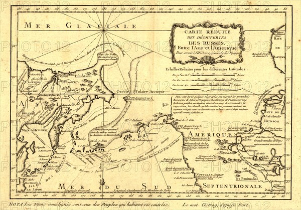
Reduced map of Russian discoveries, between Asia and America, (1747?). This French map of Alaska, Siberia, and the North Pacific, published in 1747, was based upon geographical information gleaned from earlier Russian voyages. It was created by the French cartographer, Jacques-Nicolas Bellin (1703-72), and published by the French author, Abbe´ Pre´vost. Trained as a hydrographer, Bellin was attached to the French Marine Office and specialized in producing maritime maps showing coastlines. In 1764 he published Le Petit Atlas Maritime (Small maritime atlas), a work in five volumes containing 581 maps. This map outlines the routes taken on the voyages by Semen Dezhnev around the Chukotka Peninsula in 1648; Vitus Bering through what became known as the Bering Strait in 1728; Mikhail Gvozdev and Ivan Fyodorov through the Bering Strait to Cape Prince of Wales in Alaska in 1732; and Vitus Bering and Aleksei Chirikov to southern Alaska in 1741. The map includes specific and accurate details on the Russian Asian coast south to Japan, as well as Sakhalin Island and the Kurile Islands. It also shows parts of California, which were known from Spanish explorations, as well as interior sections of North America near Hudson Bay.
Crédit
Photo12/Heritage Images/Heritage Art
Notre référence
HRM24A00_070
Model release
NA
Property release
NA
Licence
Droits gérés
Format disponible
26.6Mo (2.4Mo) / 30.9cm x 21.6cm / 3647 x 2551 (300dpi)