Sujet
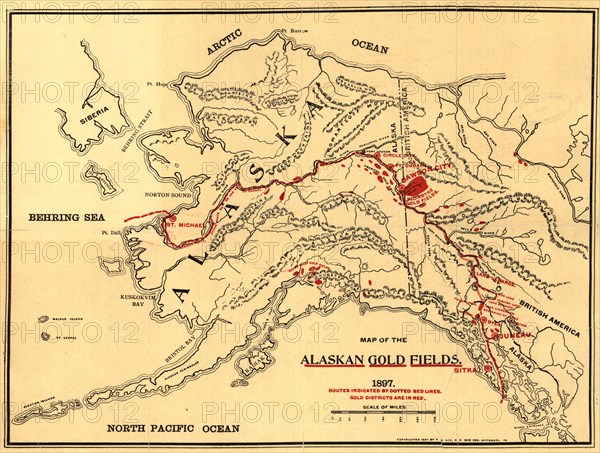
Map of the Alaskan gold fields, 1897. Creator: T. S. Lee.
Légende
Map of the Alaskan gold fields, 1897. Beginning in the mid-19th century, gold was discovered in a succession of strikes along the western coast of the United States in an ascending arc from California to Alaska. The great California Gold Rush of 1849 was followed by many other rushes" in succeeding decades, culminating in the Klondike Gold Rush of 1897 and the Nome Gold Rush of 1899, both in Alaska. This map was published in 1897, soon after gold was discovered in Bonanza Creek alongside the Klondike River, itself a tributary of the mighty Yukon River. The rush to the Klondike proved to be one of the largest in history, and was captured in the legendary poetry and prose of Robert W. Service (1874-1958) and Jack London (1876-1916). As this map shows, there were many other gold strikes in Alaska: along the Yukon River, in Juneau and other parts of Southeast Alaska, and in the Cook Inlet region (near present-day Anchorage). The map shows the most significant gold fields up to this time, highlighted in red, as well as the names of mountain chains, rivers, and other prominent geographical features in Alaska, Yukon, and British Columbia.
Crédit
Photo12/Heritage Images/Heritage Art
Notre référence
HRM24A00_025
Model release
NA
Property release
NA
Licence
Droits gérés
Format disponible
29.3Mo (2.3Mo) / 31.1cm x 23.6cm / 3679 x 2782 (300dpi)