Sujet
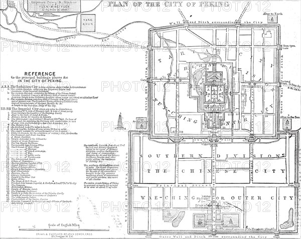
Plan of the city of Peking, 1860. Creator: John Dower.
Légende
Plan of the city of Peking, 1860. 'Peking or Pekin (Chinese Pihking, "the northern capital"), the capital of the province of Chili, is also the chief city of China and the modern metropolis of the Chinese empire. It is situated on a sandy plain, between the Peiho and its affluent the Hoen-ho, a hundred miles north-west of the mouth of the former river in the Yellow Sea, and fifty miles south of the great wall of China. The population of the city is estimated at 2,000,000. Pekin consists of two contiguous cities, each separately encircled by lofty walls, and, together, entered by sixteen gates, and occupying an area of from twenty-five to twenty-eight square miles, though much of this space is occupied by gardens and inclosures...The inner inclosure, or "forbidden city," with walls two miles in circumference, faced with yellow tiles, and surrounded by a moat faced with masonry, is appropriated to the public and private palaces of the Emperor and Empress, and has a magnificent temple of the Imperial ancestors, pavilions, gardens, a lake, and an artificial mountain. Outside of both cities are open suburbs; and Pekin has, besides its numerous temples and pagodas, a fine mosque, a Greek church and convent, and a Roman Catholic chapel'. From "Illustrated London News", 1860.
Crédit
Photo12/Heritage Images/The Print Collector
Notre référence
HRM23B08_273
Model release
NA
Property release
NA
Licence
Droits gérés
Format disponible
56.0Mo (3.3Mo) / 42.0cm x 33.4cm / 4960 x 3949 (300dpi)