Sujet
'Port of London Authority - Map', 1937. Creator: Unknown.
Légende
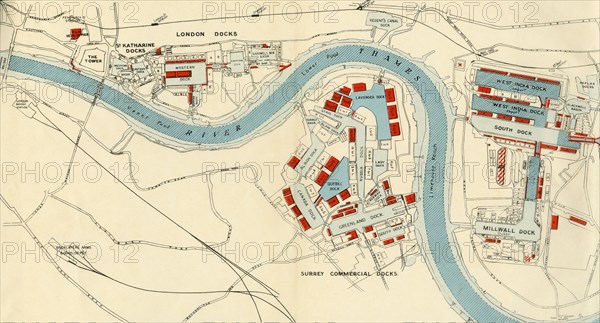
'Port of London Authority - Map', 1937. The River Thames in London, showing Tower Bridge, the Tower of London, St Katharine Docks, Western and Eastern Docks, West India Docks, Blackwall Basin, Upper and Lower Pools, Fenchurch St., Leman St., Shadwell, Stepney, West India Dock and Millwall Junction stations, Limehouse Reach, Regent's Canal Dock, Shadwell New Basin, West India Docks, Poplar Docks, Millwall Dock, Surrey Commercial Docks: Lavender, Stave, Island, Albion, Lady, Russia, Quebec, Canada, Norway, Greenland and South Docks. From "The Said Noble River", by Alan Bell. [The Port of London Authority, London, 1937]
Crédit
Photo12/Heritage Images/The Print Collector
Notre référence
HRM23A08_437
Model release
NA
Property release
NA
Licence
Droits gérés
Format disponible
53.1Mo (3.7Mo) / 49.7cm x 26.8cm / 5866 x 3166 (300dpi)