Sujet
Plan of Petropaulovski, 1854. Creator: Unknown.
Légende
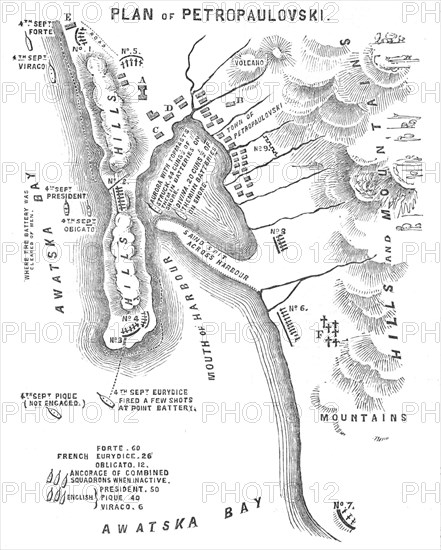
Plan of Petropaulovski, [Kamchatka], 1854. Crimean War: map showing '...position of the [Allied] Fleet and [Russian] Batteries', the town, mountains, harbour etc. 'Magazine; Government House; Landing-place; Barracks; Fish-house; Cemetery; Gorge Battery, 5 guns; Saddle Battery, 7 guns; Point Battery, 5 guns; Inner Battery, 5 guns; Path Battery, 5 guns; Snake-in-Grass Battery, 11 guns; Parkers's Battery, 3 guns; Garden Battery, 5 guns; Citadel Battery, number of guns unknown...the squadron made their way to Awatska Bay, the approach to which is very grand - high mountains (volcanoes) appearing on either side, covered with snow, and looking magnificent amongst the clouds. On one side of the bay...we perceived a lighthouse; in front of which, and commanding the entrance, is a large gun, which, as we neared the land, was fired, to give the alarm to the batteries and town...'. From "Illustrated London News", 1854.
Crédit
Photo12/Heritage Images/The Print Collector
Notre référence
HRM22B08_100
Model release
NA
Property release
NA
Licence
Droits gérés
Format disponible
13.4Mo (809.4Ko) / 16.4cm x 20.4cm / 1938 x 2414 (300dpi)