Sujet
Fortifications of Bomarsund, 1854. Creator: Unknown.
Légende
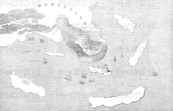
Fortifications of Bomarsund, 1854. Crimean War. Map of Russian forts on the Baltic Sea coast in Findland. Also shown are positions of the 'English' and French armies, and the Royal Navy ships Herefordshire, Penelope, Hecla, and Bulldog. The British and French attacked Bomarsund and demolished the fortress. 'The fortifications of Bomarsund lie on the eastern point of the largest of the Aland Islands. The principal fortress stands at the head of a semicircular bay armed with about eighty cannon in two tiers. At the back, or northern, side of the fort the land rises considerably, and the defence on that part consisted of three round towers - one on the highest ground to the west, a second in the centre, and a third to the east. A fourth work had been erected on the Island of Prasto, east of the fortress, and a mud battery was thrown up on the beach to the west'. From "Illustrated London News", 1854.
Crédit
Photo12/Heritage Images/The Print Collector
Notre référence
HRM22B08_049
Model release
NA
Property release
NA
Licence
Droits gérés
Format disponible
23.4Mo (2.2Mo) / 30.1cm x 19.5cm / 3559 x 2300 (300dpi)