Sujet
Map of the Rheingau, 1844. Creator: Unknown.
Légende
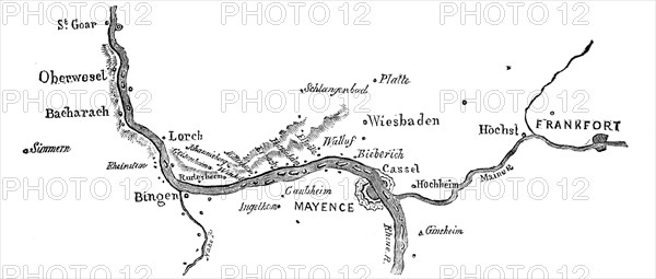
Map of the Rheingau, 1844. The Rhine in Germany: '...the small district within Wiesbaden and Bacharach, or rather, properly called the Rheingau, between Walluf and Lorch, where the Rhine vends his course from east to west. The Rheingau is but a small tract of land, and strictly on the right bank of the Rhine, only occupying an area of about 25 miles. The fertility and riches of production as to the cultivation of wine is concentrated in this little spot. It is the celebrated vineyard of Germany...Charlemagne is said to have observed from his castle, Ingelheim, how early the snow commenced melting on the Rudesheim mountain, planted Orleans grapes, and history sufficiently establishes the fact. The vineyards in the Rheingau are of considerable extent, and those belonging to Prince Metternich are the most celebrated...'. From "Illustrated London News", 1844, Vol V.
Crédit
Photo12/Heritage Images/The Print Collector
Notre référence
HRM21A06_362
Model release
NA
Property release
NA
Licence
Droits gérés
Format disponible
30.0Mo (845.5Ko) / 42.0cm x 17.9cm / 4960 x 2115 (300dpi)