Sujet
'The Estate of Charles Henry Talbot, Dodderhill, 1770', (1944). Creator: Unknown.
Légende
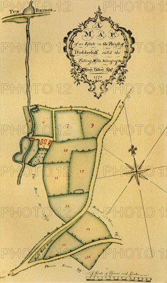
'The Estate of Charles Henry Talbot, Dodderhill, 1770', (1944). 'A Map of an Estate in the Parish of Dodderhill call'd the Fulling Mills belonging to Henry Talbot Esq'. Map showing land near Dodderhill in Worcestershire, with the names of neighbouring landowners indicated. In the collection of the Worcestershire Archive and Archaeology Service. From "British Maps and Map-Makers", by Edward Lynam. [Collins, London, 1944]
Crédit
Photo12/Heritage Images/The Print Collector
Notre référence
HRM19G32_476
Model release
NA
Property release
NA
Licence
Droits gérés
Format disponible
61.5Mo (2.9Mo) / 30.2cm x 51.0cm / 3571 x 6024 (300dpi)