Sujet
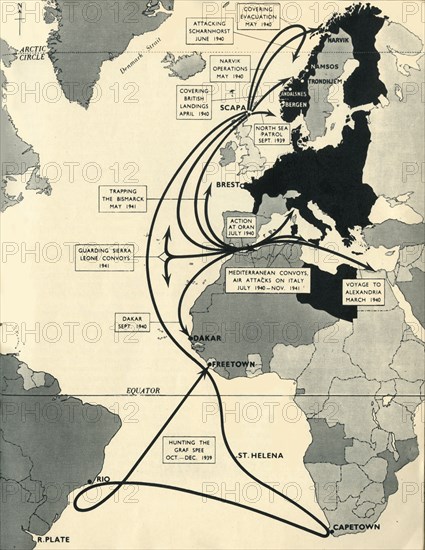
Map showing the movements of 'HMS Ark Royal', 1939-1941, (1942). Creator: Unknown.
Légende
Map showing the movements of 'HMS Ark Royal', 1939-1941, (1942). Map of the Atlantic Ocean, western Europe and Africa, indicating journeys and principal engagements of the British Royal Navy aircraft carrier 'Ark Royal' during the Second World War: Hunting of the 'Graf Spee', October-December 1939; Guarding Sierra Leone Convoys, 1941; Trapping the 'Bismarck', May 1941; Covering British Landings, April 1940; Attacking 'Scharnhorst', June 1940; Covering Evacuation, May 1940; Narvik Operations, May 1940; North Sea Patrol, September 1939; Action at Oran, July 1940; Mediterranean Convoys, Air Attacks on Italy, July 1940-November 1941; Voyage to Alexandria, March 1940. A German submarine torpedoed her on 13 November 1941 and she sank the following day. Only one of her 1,488 crew members was killed. From "Ark Royal". [His Majesty's Stationery Office, London, 1942]
Date
1942
Crédit
Photo12/Heritage Images/The Print Collector
Notre référence
HRM19F35_128
Model release
NA
Property release
NA
Licence
Droits gérés
Format disponible
63.0Mo (2.5Mo) / 35.0cm x 45.1cm / 4128 x 5332 (300dpi)