Sujet
'Map showing...the Attack on Verdun' northern France, First World War, 1916, (c1920). Creator: Unknown.
Légende
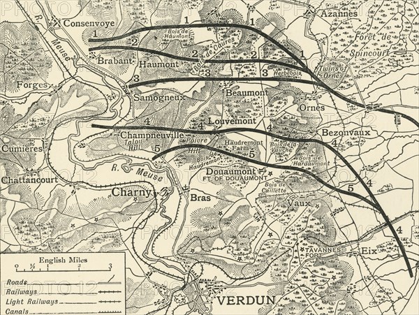
'Map showing the Various Stages in the First Phase of the Attack on Verdun' northern France, First World War, 1916, (c1920). 'The German attack on the French lines at Verdun began on the east side of the [River] Meuse at dawn on February 21, 1916. The most northerly line drawn on the map shows the French position at the time of the German onset. The other lines show the successive positions taken up by the French as they were forced back on February 22, 23, 24, and 25. On Friday, February 25, the final adjustment of the French line in the first phase of the struggle east of the Meuse took place. It crossed Poivre Hill and Douaumont Plateau'. From "The Great World War: A History", Volume V, edited by Frank A Mumby. [The Gresham Publishing Company Ltd, London, c1920]
Date
1916
Crédit
Photo12/Heritage Images/The Print Collector
Notre référence
HRM19F27_334
Model release
NA
Property release
NA
Licence
Droits gérés
Format disponible
63.1Mo (6.4Mo) / 45.8cm x 34.5cm / 5412 x 4074 (300dpi)