Sujet
'Kal'at Ja'abar', c1915. Creator: Mark Sykes.
Légende
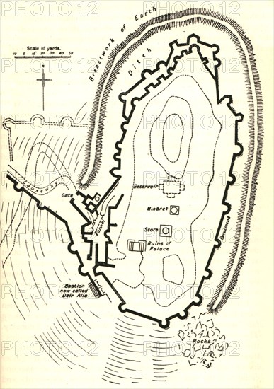
'Kal'at Ja'abar', c1915. Map of the fortress and citadel at Ja'aber, al-Tabqa city, on the left bank of the Euphrates, (Syria). 'The fortress...probably dates from the ninth century...The wonderful ruin of Kal'at Ja'abar ("formidable castle") stands out against the sky on a solitary tell. Its red walls are perched upon the overhanging mushroom cliffs of the hill, and in the centre rises a noble minaret, a landmark for miles around, which was doubtless built for purposes of observation as well as for calling the faithful to prayer. The accompanying plan, which I made on the spot and which I think is fairly accurate, will give a better idea of the size and form of the castle than pages of description'. From "The Caliphs' Last Heritage, a short history of the Turkish Empire" by Lt.-Col. Sir Mark Sykes. [Macmillan & Co, London, 1915]
Date
1915
Crédit
Photo12/Heritage Images/The Print Collector
Notre référence
HRM19F27_026
Model release
NA
Property release
NA
Licence
Droits gérés
Format disponible
47.5Mo (2.1Mo) / 28.9cm x 41.1cm / 3418 x 4857 (300dpi)