Sujet
Map Illustrating the Eastward Move from Eerstefabrieken to Middelburg', 1901.
Légende
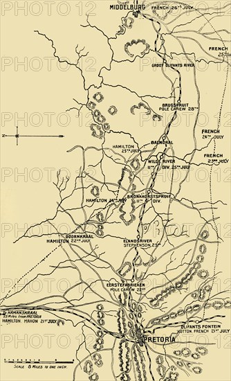
'Map Illustrating the Eastward Move from Eerstefabrieken to Middelburg', 1901. The Second Boer War (1899-1902) was fought between the British Empire and two Boer states, the South African Republic (Republic of Transvaal) and the Orange Free State. The names French, Hutton etc refer to British positions under John French, Edward Hutton and other commanders. From "The Life and Deeds of Earl Roberts, Vol. IV. - To Lord Roberts's Reign in Pall Mall", by J. Maclaren Cobban. [T. C. & E. C. Jack, Edinburgh, 1901]
Date
1901
Crédit
Photo12/Heritage Images/The Print Collector
Notre référence
HRM19F15_407
Model release
Non
Licence
Droits gérés
Format disponible
60.4Mo (2.9Mo) / 30.3cm x 49.9cm / 3582 x 5892 (300dpi)