Sujet
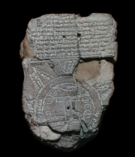
Map of the World, probably from Sippar, southern Iraq, Babylonian, c700-c500 BC. Artist: Unknown
Légende
Map of the World, probably from Sippar, southern Iraq, Babylonian, c700-c500 BC. This tablet contains both a cuneiform inscription and a unique map of the Mesopotamian world. Babylon is shown in the centre and Assyria, Elam and other places are also named. The central area is ringed by a circular waterway labelled 'Salt-Sea'. The outer rim of the sea is surrounded by what were probably originally eight regions, each indicated by a triangle, labelled 'Region' or 'Island', and marked with the distance in between. The purpose of the map is to explain the Babylonian view of the mythological world. From the British Museum's collection.
Date
700e siècle av. J.-C.
Crédit
Photo12/Heritage Images/CM Dixon
Notre référence
HRM19B79_094
Model release
Non
Licence
Droits gérés
Format disponible
50.4Mo (1.9Mo) / 33.0cm x 38.3cm / 3894 x 4524 (300dpi)