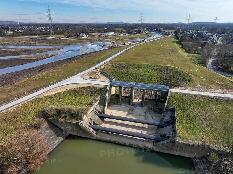
Dinslaken, Voerde, North Rhine-Westphalia, Germany - Former Emscher estuary into the Rhine. Renaturalisation of the Emscher. The mouth of the Emscher into the Rhine has been moved almost 500 metres north from Dinslaken to Voerde. Fish can now swim barrier-free up the new Emscher from the Rhine through a newly created floodplain area. Following the construction of a parallel sewer, the Emscher has been completely free of sewage since January 2022. The river was previously an open, above-ground combined sewer with rainwater and wastewater
Légende

Dinslaken, Voerde, North Rhine-Westphalia, Germany - Former Emscher estuary into the Rhine. Renaturalisation of the Emscher. The mouth of the Emscher into the Rhine has been moved almost 500 metres north from Dinslaken to Voerde. Fish can now swim barrier-free up the new Emscher from the Rhine through a newly created floodplain area. Following the construction of a parallel sewer, the Emscher has been completely free of sewage since January 2022. The river was previously an open, above-ground combined sewer with rainwater and wastewater

Date

18 févr. 2025

Crédit

Photo12/ImageBROKER/Rupert Oberhäuser

Notre référence

BRK26J49_279

Model release

NA

Property release

Non

Licence

Droits gérés

Format disponible

59.8Mo (19.9Mo) / 44.7cm x 33.5cm / 5280 x 3956 (300dpi)

Mots clés

parallel View from above deserted new meter construction site modification flood vegetation water dike delta river wetland body of water climate meadow Fish wild animal biotope animal ecological conservation global warming nature Ruhr district North Rhine-Westphalia Rhine German wildlife flora Europe construction work estuary climate protection open climate change natural riverbed Aerial river bank riverbank waterway water treatment landscape flooded european sewage five hundred burden water animal River landscape accessible water protection contamination former preparation northern Germany sewerage flood control marshland project looking down landscape conservation overground wildlife photography Voerde Dinslaken contaminated Emscher natural environment river course wetland landscape Central Europe drone photography climate crisis meadow landscape Emscher sewer state sector Public services Wastewater treatment Emscher Estuary floodplain River system wastewater-free Emscher conversion Sewer River renaturalisation Infrastructure project River dyke high-angle view no one newly metre building site alteration flooding waterfront dyke river delta wet land waters lawn animals in the wild nature protection open air Ruhr area NRW fauna plant life river mouth climate control opened original river bed aerial photography shore canal water purification scenery effluent stress riverine landscape handicapped access pollution German Federal Republic sewerage system flood protection marsh view down landscape preservation above-ground dirty habitat course of a river Middle Europe drone image grassland landscape Services of general interest flood plain top down view No People construction area conversion high water embankment wetland biotope field Wildlife Ruhr Federal State of North Rhine-Westphalia watershore riverside water canal countryside wastewater 500 river scenery disabled friendly polluting Republic of Germany flood prevention alluvium landscape protection polluted natural habitat nobody floodwater Ruhr region North-Rhine Westphalia channel landscape shot Riverscape barrier-free FRG alluvial land uninhabited Ruhrgebiet landscape photo disabled empty handicapped accessible elevated view meters construction sites modifications floods vegetations dikes deltas rivers wetlands climates meadows wild animals biotopes animals construction works estuaries riverbeds Aerials aerial view aerial shot river banks riverbanks waterways water treatments landscapes sewages burdens water animals River landscapes contaminations formerly preparations sewerages projects natural environments floodplains high-angle shot metres building sites dykes river mouths originally airshot shores canals sceneries effluents riverine landscapes drone shot photo with drone embankments watershores water canals Waste water river sceneries bird's eye view BRD alluvial from above overhead water flood water body Water area open water Grass field Europe's building confluence aerial photo aerial photos banks of landscape photograph River view north sewer flood water control with a drone from a drone aerial drone top view top views Top angle Aerial landscape aerial photograph course of the river drone photograph drone recording top down flight photo flight photos flight shot flight shots from the sky from the air water shore drone photo drone photos drone view birds eyes view Bird eye view bird view bird perspective

Connectez-vous pour télécharger cette image en HD