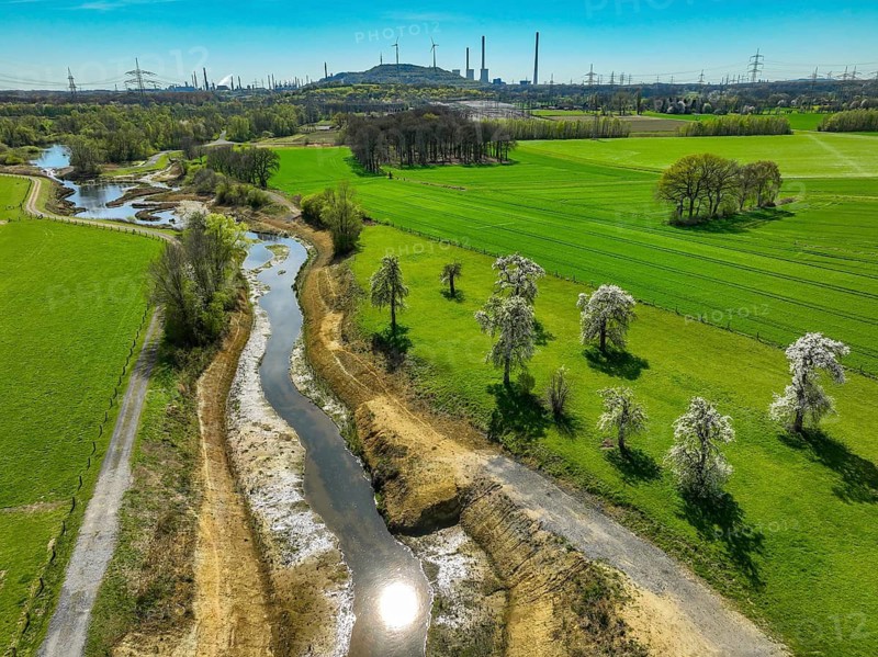
Dorsten, North Rhine-Westphalia, Germany - Renaturalised Rapphofs (also Rapphoffs) Mühlenbach, tributary of the Lippe, Lippe system, behind the Oberscholven wind farm slagheap in Gelsenkirchen. Expansion of the area for flood protection during heavy rainfall and for biodiversity. The previously straightened stream is given curves again and can meander through its new floodplain
Légende

Dorsten, North Rhine-Westphalia, Germany - Renaturalised Rapphofs (also Rapphoffs) Mühlenbach, tributary of the Lippe, Lippe system, behind the Oberscholven wind farm slagheap in Gelsenkirchen. Expansion of the area for flood protection during heavy rainfall and for biodiversity. The previously straightened stream is given curves again and can meander through its new floodplain

Date

07 avr. 2026

Crédit

Photo12/ImageBROKER/Rupert Oberhäuser

Notre référence

BRK26H05_152

Model release

Non

Property release

Non

Licence

Droits gérés

Format disponible

59.8Mo (19.9Mo) / 44.7cm x 33.5cm / 5280 x 3956 (300dpi)

Mots clés

View from above new water level farmland agriculture alternative energy power generation power supply curve industry flood catastrophe destruction misfortune planning tree vegetation element water landscaping creek river wetland body of water climate meadow biotope environment protection global warming environment season Gelsenkirchen Ruhr district North Rhine-Westphalia German flora Europe wind park plain cultural landscape natural preserve wind power reserve agricultural climate protection climate change culture autumn natural riverbed Aerial river bank riverbank acreage road rural flow autumnal damage industrial commercial area electricity ecofriendly flooded wind infrastructure energy energy source european renaturation industrial area power industry destroyed nature reserve system River landscape creep windy Germany renewable ecological awareness flood control project sustainability looking down landscape conservation renaturated generation of current environmental issue Dorsten Lippe landscape conservation area countryside Lippeauen natural environment course of a stream river course wetland landscape meander Central Europe drone photography climate crisis meadow landscape Industry landscape wind turbine Mühlenbach floodplain Biodiversity Flood disaster River system River renaturalisation Shire Climate catastrophe Infrastructure project Landscape planning flatland high-angle view newly cropland farming green energy energy production electricity supply bend flooding disaster waterfront brook wet land waters lawn environmental protection Ruhr area NRW plant life wind farm cultivated landscape nature park protected area agrarian climate control fall original river bed aerial photography shore cultivated area street pour industrial estate eco-friendly high tide industrial zone energy industry wrecked riverine landscape lowland German Federal Republic regenerative environmental awareness flood protection view down landscape preservation renaturalised generation of electricity landscape protection area in the country habitat stream course of a river Middle Europe drone image grassland landscape Industrial landscape wind energy plant flood plain Flood top down view field renewable energy energy supply high water wetland biotope environmental conservation Ruhr Federal State of North Rhine-Westphalia windfarm Naturpark wind energy sanctuary watershore riverside environmentally friendly Industrial district bust nature conservation area river scenery Republic of Germany sustainable flood prevention landscape protection Power generation Landscape protection natural habitat wind power plant Pastureland floodwater little River Ruhr region North-Rhine Westphalia conservation area Environmental friendly broken natural reserve Riverscape FRG electricity generation Pastures small river Ruhrgebiet damaged environmental reserve Wind energy wheel Arable land defective wind power station farm field corrupted wind generator Windpower generator elevated view water levels farmlands alternative energies power generations power supplies curves industries floods catastrophes destructions misfortunes plannings trees vegetations elements creeks rivers wetlands climates meadows biotopes seasons wind parks plains cultural landscapes natural preserves reserves agriculturally cultures riverbeds Aerials aerial view aerial shot river banks riverbanks acreages roads flowing Autumnally damages commercial areas winds infrastructures energies energy sources industrial areas power industries nature reserves systems River landscapes creeping projects environmental issues landscape conservation areas natural environments meandering wind turbines floodplains Flood disasters high-angle shot bends brooks wind farms cultivated landscapes originally airshot shores streets pouring high tides industrial zones riverine landscapes lowlands drone shot photo with drone wind energy plants Floods fields windfarms watershores river sceneries winding wind power plants bird's eye view BRD Wind energy wheels wind power stations wind generators Windpower generators from above overhead farm land turn turns water flood water body Water area open water Grass field Europe's Autumn Season fall season aerial photo aerial photos banks of Straße flows industrial park industrial parks NSG River view creeps flood water control course of meanders with a drone from a drone aerial drone top view top views Top angle natural park Aerial landscape aerial photograph course of the river drone photograph drone recording top down flight photo flight photos flight shot flight shots from the sky from the air water shore drone photo drone photos drone view birds eyes view Bird eye view bird view bird perspective

Connectez-vous pour télécharger cette image en HD